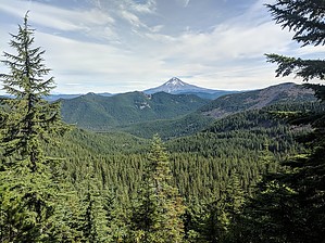
This trail is in the Roaring River Wilderness. This trail begins at Forest Road 4610-240 (4,680’) and ends at Shining Lake (3,920’). From Forest Road 4610-240, travel north-northwest on Indian Ridge. There are great views of Mount Hood, Mount Rainier, Mount St. Helens, and Mount Adams in the first mile. Continue along Indian Ridge for 3.6 miles to the junction with a spur trail heading to the old Indian Ridge fire lookout (0.4 mile). Take the right fork onto this trail (#510) and continue down the switchbacks 0.7 mile to Shining Lake.
When hiking several trails on a single "hike", log it with a generic name that describes the hike. Then link the trails traveled, check out the example.
WARNING! Hiking and outdoor related sports can be dangerous. Be responsible and prepare for the trip. Study the area you are entering and plan accordingly. Dress for the current and unexpected weather changes. Take plenty of water. Never go alone. Make an itinerary with your plan(s), route(s), destination(s) and expected return time. Give your itinerary to trusted family and/or friends.
To hike From Portland, OR - travel east on US Hwy 26 to Sandy. Turn right (southwest) on OR Hwy 211 and travel 6.1 miles to OR Hwy 224. Turn left (southeast) on OR Hwy 224 and travel 30.2 miles to Oak Grove Fork Road (Forest Road 57) (approximately at milepost 50).
Turn left (east) on Oak Grove Fork Road and travel 7.4 miles to High Rock Road (Forest Road 58). Turn left (north) and travel 5.8 miles to Forest Road 4610. Turn left onto Forest Road 4610 and travel 1.2 miles to Forest Road 4610-240.
Follow Forest Road 4610-240 for 4.4 miles to Frazier Turnaround and the trailhead.
 Route Editor


