 Route Editor

| Guide | ♦ | 5 Triplogs | 0 Topics |
details | drive | permit | forecast | 🔥 route |
stats |
photos | triplogs | topics | location |
| 21 | 5 | 0 |
No scenery for you! by nonot 11.4 mi / 1,650 aeg / 5 hours The trail can be followed further to Verna Lake, Spirit Lake, Fourth Lake, and beyond. However, snow, nightfall, and hitting the marathon mark (26 miles in a single day) prevented me from making it past Lone Pine on my first attempt. Statistics above and to the left only reflect the Lone Pine Lake Portion. Add about 2 miles for Verna, maybe 0.75 for Spririt, and another 0.5 for Fourth.
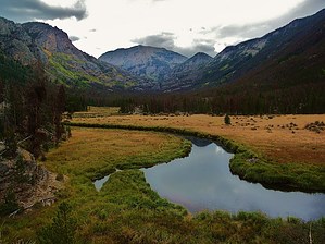
Hike: Imagine a gorgeous canyon with snow-melt fed streams, waterfalls, and cascades. Your job, if you were the trail builder, is to avoid all the scenic spots and build the East Inlet trail next to ugly rock escarpments, muddy bogs, and route the trail 200 yards away from any waterfall. Plus, for kicks through in some extra unnecessary elevation. From the Trailhead, walk a short distance uphill until you see the turnoff for Adams Falls Loop. Take the turn to the right and view the falls. The falls are pretty impressive, powerful, and in early June, strewn with logs and trees. Continue along the loop trail until you reach the junction with East Inlet and turn right onto the trail. Heading a bit more uphill you will reach a spectacular view of a gorgeous meadow. The snow capped peaks in the distance are set against the winding creek in a lush, green meadow. Take it all in. I recommend you turn around and head to your car, having hiked 2 miles. Noticing that there are some 10 miles still to hike, let's pretend you want to waste the rest of your day. Continue climbing uphill along the trail. You will hear sounds of waterfalls, cascades, but you will not get close enough to see them! At one point the trail makes a meager attempt to get to what is a pretty impressive waterfall, but climbs down from above the falls and goes too far above it to get any good views of the water. From this point continue to climb, now in the mud, until you finally reach Lone Pine Lake. View Lone Pine Island, a solitary piece of rock with, what I presume, originally just had one pine tree growing on it. The tree is long gone as there are several decade or two old trees fighting for space. Lone Pine Lake is really wonderful, but whether it is worth the 5 miles each way to see it from the meadow is debatable. If you do intend to go this far, I'd recommend planning for a full day hike so you can see Verna, Spirit, and Fourth Lakes. I imagine they would be gorgeous. Unfortunately in early June, the trail disappeared into snow and it was beginning to get dark, so I could not determine where the trail goes after Lone Pine Lake. Water Sources: Plenty with a filter Camping: There were dispersed sites marked throughout the whole trail, however I saw few flat spots. The Pine Mountain Beetle has destroyed 80% of the trees in this valley so any flat areas are littered with tree trunks falling every which way. There are signs all over Lone Pine Lake that indicate no camping there. Check out the Official Route and Triplogs. Leave No Trace and +Add a Triplog after your hike to support this local community. One-Way Notice This hike is listed as One-Way. When hiking several trails on a single "hike", log it with a generic name that describes the hike. Then link the trails traveled, check out the example. | |||||||||||||||||||||||||||||||||||||||||||||||||||||||||||||||||||||||||||||||||||||||||||


