Route Editor

| Guide | ♦ | 2 Triplogs | 0 Topics |
details | drive | permit | forecast | 🔥 route |
stats |
photos | triplogs | topics | location |
| 4 | 2 | 0 |
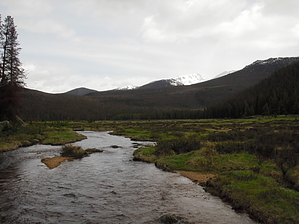
You can't pronounce it, but it's a fun hike! by nonot This hike starts near the town of Grand Lake and gradually climbs into the Rockies. This description stops at Big Meadows, which coincides with the intersection of the Green Mountain Trail. This is a popular horse route, watch for landmines. Warning Afternoon storms are common in the Rockies, bring a warm hat and a waterproof jacket so that you'll be equipped for snow and rain.
From the trailhead, begin hiking north along the Tonahutu Creek. The trail will parallel the creek throughout the hike. In the beginning, there were a few downed trees to hop over, but I did encounter several people clearing the trails further on, so the park service seems to take maintenance of this trail seriously. In about a mile you will pass a junction with a trail that heads towards the lodge. Soon afterwards, you will pass a trail that could take you to the visitor center on the west side of the park. Staying on the Tonahutu Creek Trail, continue to climb gradually uphill. Certain areas of the Rockies have been devastated by the Mountain Pine Beetle as of this writing (June, 2009), so you will observe areas of patchy forest with much fallen timber scattered about. Hopping over some muddy spots, the trail begins to follow the creek much more closely. You begin to notice that to your east, the forest has retreated away from the creek. Soon you are trying to peak out and north to see how big the clearing gets. Finally, after about 5 miles, you will reach the sign for Big Meadows, which is a backcountry camping site. Hang a left and walk a hundred yards to the intersection with the Green Mountain trail to orient yourself. Now walk back to the Big Meadows sign and head towards the creek. A log serves as a pretty good bridge and past that you will have to hurdle some of the fingerlets of the creek. The meadow is expansive, several miles long, and deserves the name "Big Meadows". If you want to check out the campgrounds continue to the other side of the creek, there is a privy hidden in the campgrounds. I encountered two rangers, who, after shooting the breeze a bit, disclosed they were packing out garbage and gear left by previous horse-packers. Pack out your crap! I left them as they were taking care of a log strewn across the trail with a handsaw, as they couldn't bear to make the chainsaw guy come all the way out there for one log. Return the way you came. Water Sources The entire trail runs along a creek, bring a filter! Camping Big Meadows has several campsites. To camp in RMNP you will need a backcountry camping permit. Check out the Official Route and Triplogs. Leave No Trace and +Add a Triplog after your hike to support this local community. | |||||||||||||||||||||||||||||||||||||||||||||||||||||||||||||||||||||||||||||||||||||||||||