 Route Editor

| Guide | ♦ | 77 Triplogs | 0 Topics |
details | drive | no permit | forecast | route |
stats |
photos | triplogs | topics | location |
| 144 | 77 | 0 |
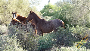
Ain't no scorpions... just wild horses by CannondaleKid  Overview OverviewScorpion Trail is another mountain bike trail added to the Hawes Trail System in December 2018. This trail links the Wild Horse Trail to the fence-opening at the horse crossing on Bush Highway near Milepost 226. (Near the Salt River Tubing lot) It begins at a point along Wild Horse Trail just over 3 miles from Bush Highway from the west, or about a mile from Usery Pass Road, passing through the gravel pit. Warning This trail is designed for and primarily to be used by mountain bikers, but you may encounter hikers, equestrians, and yes, even wild horses, so be aware. (I passed through three separate groups of wild horse on the hike)
The Forest Service authorized the Scorpion Trail. An environmental assessment was performed in 2008... it just took ten years before it moved forward. And move forward it did, with the trail being constructed over the first weekend in December 2018. NOTE The Forest Service authorized neither the nearby High Horse and Horse Tale trails, and needless to say, they are not happy about it. The reason I mention it here is the Forest Service urges the general public to help by reporting any out-of-the-ordinary or perceived illegal activity. For example: If you observe new trail construction without any Forest Service employees present, contact the Mesa Forest Service office at 480-610-3300 Mountain Bike Easy single-track trail with a nice flowing rhythm on a hard-packed gravel surface (some grass at the moment) featuring short straights, turns with curved berms, and a few jumps along with a very minor but steady loss of elevation. It will be a while yet before I'm able to bike it, but from the looks of it, there will be some high-speed sections where one could easily reach 25-30 mph... especially for the younger riders who have yet to break enough bones to slow them down. Hike Very easy... no sandy washes, no thorny stuff, just a nice hard-packed surface. Due to the area being so flat, most scenery is the Palo Verde & Ironwood trees and vegetation, including jojoba, cholla, ocotillo, etc. Water Sources None - Bring your own. Oh yeah, please don't leave empty bottles along the trail or where you park. Check out the Official Route and Triplogs. Leave No Trace and +Add a Triplog after your hike to support this local community. One-Way Notice This hike is listed as One-Way. When hiking several trails on a single "hike", log it with a generic name that describes the hike. Then link the trails traveled, check out the example. | |||||||||||||||||||||||||||||||||||||||||||||||||||||||||||||||||||||||||||||||||||||||||||||||||||||||||||||||||||||||||||||||||||||||||||||||||||||||||||||||||||||||||||||||||||||||||


