 Route Editor

| Guide | ♦ | 2 Triplogs | 0 Topics |
details | drive | no permit | forecast | route |
stats |
photos | triplogs | topics | location |
| 42 | 2 | 0 |
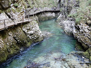
History Until 1890, the gorge was mainly inaccessible, except for two points at which the Radovna could be reached, and a bridge over Šum Falls was already built in 1878. The rest of the gorge was explored in 1891 by the mayor of Gorje, Jakob Žumer, and by Benedikt Lergetporer, a prominent photographer of the era.
A hydroelectric dam has also been built below the gorge and an arch railway bridge for the Bohinj Railway. The bridge, built in 1904 and 1905 of cut stone, is the largest stone arch railway bridge preserved in its entirety in Slovenia. It is 65 m (213 ft) long, 4.5 m (15 ft) wide and 33 m (108 ft) high. Geology Before the last ice age, the Radovna River flowed eastward. After being dammed by the ice and detritus of the Bohinj Glacier, the resulting lake cut a new path northeast through a soft layer of triassic limestone between the hills Boršt (931 m or 3,054 ft) and Hom (844 m or 2,769 ft), towards the Upper Sava Valley. Source Wikipedia Check out the Official Route and Triplogs. Leave No Trace and +Add a Triplog after your hike to support this local community. One-Way Notice This hike is listed as One-Way. When hiking several trails on a single "hike", log it with a generic name that describes the hike. Then link the trails traveled, check out the example. | ||||||||||||||||||||||||||||||||||||||||||||||||||||||||||||||||||


