username
X
password
register
for free!
help
 This is likely a great time to hike this trail!  Check out "Preferred" months below, keep in mind this is an estimate.
   🔥

Cerre Grande, NM

Guide 1 Triplog  0 Topics
  3 of 5  
Fav
Wish
0
details
drive
permit
forecast
🔥
route  
stats
photos
triplog
topics
location
6 1 0
Statistics
tap row or icons for details
Difficulty 2.5 of 5
Distance One Way 4.61 miles
Trailhead Elevation 8,952 feet
Elevation Gain 1,223 feet
Accumulated Gain 1,252 feet
Kokopelli Seeds 8.78
unreported if dogs are allowed
editedit > ops > dogs to adjust
feature photo
Photos Viewed All MineFollowing
6  2018-10-03 rvcarter
Author
author avatar Guides 16,843
Routes 17,472
Photos 24
Trips 1 map ( 6 miles )
Age 28 Male Gender
Location HAZ, TrailDEX
Co-Author
co-author avatarGuides 36
Routes 310
Photos 2,235
Trips 241 map (1,467 Miles)
Age 79 Male Gender
Location tucson, az
Associated Areas
list map done
North Central Region
Historical Weather
Trailhead Forecast
Radar Map
Expand Map
Preferred Sep, Jun, Aug, Jul
Sun  5:40am - 6:28pm
Official Route
 
0 Alternative
 
Historic Fire Perimeteracres
🔥 2011 Las Conchas Fire0


remove free decal offer

 Likely In-Season!
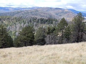
Cerre Grande is located in, and is the highest point in, the Bandelier National Monument west of Los Alamos. The large parking lot for the trailhead is at the junction of Rt. 4 and St. Peters Dome Road, FR 289. The trail is great and a lot of fun, but the sweeping views of the Valles Caldera, from the top are what make this hike a top choice. Not many people get out this far from Sante Fe, so no crowds. This hike was part of our hiking club outing to Sante Fe in early October. Great moderate hike. Even though the trail is not maintained, it’s in good shape.


2018-12-20 HAZ_Hikebot & rvcarter
  • nps related


Check out the Official Route and Triplog.
Leave No Trace and +Add a Triplog after your hike to support this local community.

One-Way Notice
This hike is listed as One-Way.

When hiking several trails on a single "hike", log it with a generic name that describes the hike. Then link the trails traveled, check out the example.
WARNING! Hiking and outdoor related sports can be dangerous. Be responsible and prepare for the trip. Study the area you are entering and plan accordingly. Dress for the current and unexpected weather changes. Take plenty of water. Never go alone. Make an itinerary with your plan(s), route(s), destination(s) and expected return time. Give your itinerary to trusted family and/or friends.

 Permit $$
no fees or permits reported

if incorrect tell us about it

Bandelier National Monument
Fees & Passes → more info


 Directions
or
 Road


To hike
page created by joebartels on Dec 07 2018 2:44 pm
 90+° 8am - 6pm kills
helpcorrectionissue

end of page marker