 Route Editor

| Guide | ♦ | 74 Triplogs | 0 Topics |
details | drive | no permit | forecast | route |
stats |
photos | triplogs | topics | location |
| 203 | 74 | 0 |
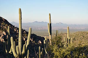
where's the Alamo by markthurman53  Overview OverviewLike all the trails in the Tortolita Mountains, the trail starts from the Wild Burro Trailhead in the trail parking lot on the Ritz Carlton Hotel's south side. The Alamo Springs Trail starts from the Wild Burro Trail just north of the Hotel. This Trail is in good condition, and all the junctions are signed and color-coded. Description About 0.6 miles up the Wild Burro Trail from the Wild Burro Trailhead is a signed junction. This is the decision point for all the trails in the Tortolitas. The Lower Javelina and Alamo Springs Trails head off to the right. Almost immediately, the trail heads up the ridge to the southeast that separates Ruelas Canyon from Wild Burro Canyon. The Lower Javelina Trail heads off to the left after about 0.2 miles at a signed junction.
From the saddle, the trail starts a rather healthy downhill section to the signed junction of the Alamo Springs Spur Trail, about 0.5 miles. At the junction, the Alamo Spring Trail heads to the right. The Alamo Springs Spur Trail is a useful trail for those wanting to hike trails further in. Using the lower Wild Burro Trail and heading up the Spur trail, you avoid all the elevation gain of the Alamo Springs Trail. After the junction with the Alamo Springs Spur Trail, the Alamo Springs Trail starts a gradual climb to a small ridge, about 0.6 miles. Views of Upper Wild Burro Canyon can be seen from this ridge. From this ridge, it is a 0.3 mile downhill walk to Alamo Spring. The Ridgeline Trail heads off to the right just below this ridge at another signed intersection. Synopsis All the trails are well marked in the Tortolita Mountains, making it difficult to get lost or confused. I did say difficult, not impossible. This trail follows along the northwest slope of the ridge that separates Ruelas Canyon from Wild Burro Canyon. This is the high road to Alamo Springs and has a lot more elevation gain than the lower trail through Wild Burro Canyon. This route's upside is that there are great views to the southwest of the Tucson Mountains, Quinlan, Baboquivari Mountains, and to the west of the Silver Bell Mountains and Ragged Top Peak. Mornings are the best times because the sun is not obscuring the views; evening if there is going to be a good sunset. About 2.7 miles in on this 3.6-mile trail is a trail heading back down into Wild Burro Canyon, and this is the Alamo Springs Spur Trail. The Alamo Spring Trail continues north for another 0.9 miles to Alamo Springs. At Alamo Springs, a small dam has been filled in with sand and a cement rock structure that use to be a well. A hundred yards to the north of the spring is the old line shack used by the early ranchers in this area. Only the lower rock walls and parts of the roof remain. The trunk of a huge Cottonwood tree lays across the wash, a reminder that this place uses to be much wetter. The only cottonwood I saw growing there is a sapling by the rock well. Immediately to the south of the well in the rock that forms this canyon's narrows, there are some grind holes used by the Hohokam Indians. Nice place to take a break knowing that others way before you enjoyed this spot also. The return trip can be back down the Alamo Spring Trail, or you can change things up by returning via the Wild Burro Trail. Check out the Official Route and Triplogs. Leave No Trace and +Add a Triplog after your hike to support this local community. One-Way Notice This hike is listed as One-Way. When hiking several trails on a single "hike", log it with a generic name that describes the hike. Then link the trails traveled, check out the example. | |||||||||||||||||||||||||||||||||||||||||||||||||||||||||||||||||||||||||||||||||||||||||||||||||||||||||||||||||||||||||||||||||||||||||||||||||||||||||||||||||||||||||||||||||||||||||||||


