Route Editor

| Guide | ♦ | 6 Triplogs | 0 Topics |
details | drive | no permit | forecast | route |
stats |
photos | triplogs | topics | location |
| 93 | 6 | 0 |
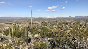
A spiritual rebirth by chumley  Overview OverviewOf all the mountain ranges in Arizona, John the Baptist might just be the smallest. But no matter, it still has a high point worth visiting. History John C. Butala lived in a shack at the eastern base of the range, marked on topo maps today as a "site". Only the foundation of a building remains. He was a veteran of both the Spanish-American War and WWI. Wiki says he was eccentric and ran around the desert in nothing but a loincloth made from gunnysacks while befriending the local wildlife. Rumors abound regarding some war-related issues he developed, but apparently his appearance and behavior as a "wild-eyed desert prophet" earned him the nickname of John the Baptist amongst the local Ajoans (Y'Ajoos?). He died in 1961 and is buried in Ajo.
There's no trail. Find your way to the east side of the range and park. There's a wash crossing that is a bit overgrown but doesn't take much effort or get you too scratched up. There might be signs of border-related use in the wash sands. The ascent is somewhat steep but the desert flora is easy to avoid and most footsteps can be made on solid lava rock or bare earth. At the crest of the hill, you find the high-point is set back several hundred yards, but attaining it is easy. The high point was the source of a huge pack-rat nest of cholla needles, but a nearby cairn contained a summit register. Return the way you came or traverse the ridgeline to the north to get the proper feel for the entirety of the range! We encountered some old trash, water bottles, food packets, and some backpacks and clothing under a tree a half-mile north of the high point. While typical for this area, it's always best to be aware of your surroundings. Check out the Official Route and Triplogs. Leave No Trace and +Add a Triplog after your hike to support this local community. | |||||||||||||||||||||||||||||||||||||||||||||||||||||||||||||||||||||||||||||||||||||