Route Editor

| Guide | ♦ | 4 Triplogs | 0 Topics |
details | drive | permit | forecast | route |
stats |
photos | triplogs | topics | location |
| 0 | 4 | 0 |
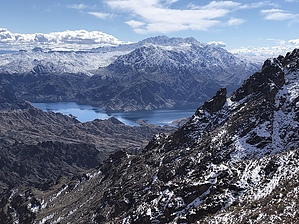
Jacal is a desert peak immediately to the northeast of Hamblin Mountain in the Black Mountains on the north side of Lake Mead. The approach to the saddle of either peak is the same route, splitting in opposite directions at the saddle. Jacal is the slightly easier peak to reach, but combining both peaks on the same hike would make the most sense. There are a couple areas of scrambling, which can be bypassed to make this hike easier. Hike From the west end of the pullout on the north side of Northshore Rd, cross the road to the south side, and head south on the trail, which is lined with rocks for the first few feet. The trail heads south, then drops into Cottonwood Wash and turns southeast. Stay in the wash as it continues in the south easterly direction. There are a few side washes that lead in, and a gps track is helpful in staying the main wash, but generally, staying in the largest wash will keep you on the correct track.
You will continue in Cottonwood Wash for close to another mile, then just before you are two miles into the hike, in an area of red rock and soil, the wash will split. Turn sharply to the right (southwest) and continue in that wash. That turn was cairned as of Feb 2019. This wash climbs a little more steeply and the vegetation increases as you gain elevation. After a little more than half a mile in this wash, the route gets somewhat vague, and climbs to the low saddle in front of you. At the top of the saddle (which was cairned) the trail becomes more distinct again, and drops down into another wash. Note where you drop into this wash, as you'll need to remember to climb back out of the wash here on your way back out. As you ascend up this wash/gully, you will head more directly south, and route finding becomes easier, although the steepness increases. After about half a mile (three miles into the hike at this point), there is another short scramble. Hand & footholds are good, and at the top of it, angle to your right to continue up the gully. If this scramble is wet or icy, it may be too difficult to ascend/descend. The posted gps track includes a wide bypass to the right if you backtrack a couple hundred feet. If you don't like scrambling, this bypass is a good option. After the scramble or bypass, the gully gets progressively steeper as you approach the saddle, but the trail is easy to follow. Just below the saddle, you'll turn left (east) for the final couple hundred feet. Once on the saddle, the views open up. Turn left (northeast) and follow the ridgeline or clearly defined use trail up to Jacal Peak. As you walk the ridgeline to the peak, there are views of the Muddy Mountains and Bowl of Fire to your left, and views of Lake Mead, and the rest of the Black Mountains to your right. The Virgin Mountains are on the horizon ahead of you, and Hamblin Mountain looms behind you. After enjoying the peak views, retrace your steps to the saddle. From here, you can return to the trailhead the same way you hiked up, or head over to the summit of Hamblin Mountain about a third of a mile away before returning to the trailhead. Check out the Official Route and Triplogs. Leave No Trace and +Add a Triplog after your hike to support this local community. | ||||||||||||||||||||||||||||||||||||||||||||||||||||||||||||||||||||||||||||||||||