Route Editor

| Guide | ♦ | 2 Triplogs | 0 Topics |
details | drive | permit | forecast | route |
stats |
photos | triplogs | topics | location |
| 4 | 2 | 0 |
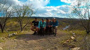
Short water access hike on Patagonia Lake by KingLeonidas   Overview OverviewBlack Hawk Trail is a short day hike from Lake Patagonia. It connects to several other trails; Coal Mine Spring Trail, New Mexico and Arizona Railroad Trail, and Sonoita Creek Trail. It features several creek crossings of easy to moderate difficulty and is a good water-access day hike for canoe camping on the lake. Access The trail can be reached from the dam/spillway parking lot or by paddle craft if you are staying at one of the boat-in campsites on the lake (the small cove southwest of campsite 117 has a spot where canoes and kayaks can be beached).
We started by landing our canoe on the shore of the lake and had to bushwhack our way over the hill, under the barbed wire fence, and around a (fortunately disinterested) bull that was grazing nearby to get to the trail. After this adventurous start, things calmed down a bit once we were actually on the trail. There was a pretty spot called Jen's Vista with a bench and an excellent view of the creek. From this point on the Patagonia Lake was no longer in view and the trail continued downhill. At ~1.2 miles in there was a stand of very old trees including a Birch of substantial size. Shortly afterward there were some old concrete ruins (possibly from an earlier damming of the creek?) and several creek crossings. We were hiking in early March after a particularly wet winter and the lake water levels were at very high levels. This made the creek crossings somewhat of a challenge. The most challenging crossing was knee-deep at the shallowest point and the water was moving fairly quickly. We crossed Sonoita Creek three times (going one way). Two of the crossings had stepping stones or a log, only one had no aids. I suspect that these crossings are normally much lower and easier to cross. At the crossing, there is a 3-way trail junction (technically it is 2 junctions with the creek running in between them). Prior to crossing Sonoita Creek Trail is on your left and makes a good alternative return route. On the far side of the creek are Coal Mine Spring Trail and New Mexico and Arizona Railroad Trail. Coal Mine Spring Trail leads to Coal Mine Spring Campsite a possible backpacking destination. Blackhawk trail ends at this point. Navigation Finding your way is not difficult from the dam parking lot. Simply walk across the spillway which is usually dry but potentially up to calf-deep if lake levels are really high (they were for us) and turn left following the creek. There is a spot about 1/4 of a mile in where you will need to bear left at the sign or you will end up following Pena Blanca Lake Road (which is little more than a jeep trail) and not the trail itself. Otherwise, the path is pretty clear. If you are taking the water access route you will have to bushwhack your way up the hill and over to the spillway to find the trail. The hill is thick with all manner of sharp and prickly overgrowth, getting through it is slow and painful. The easiest way through is to skirt the edge of the lake near campsite 117. There is also a barbed wire fence running along the top of the hill but it can be crossed without too much difficulty at a few low spots. Conditions The trail conditions are good; it is well maintained and very smooth. Conclusion Overall this is a fun easy to moderate trail that is a decent standalone option or a good connecting trail.
Check out the Official Route and Triplogs. Leave No Trace and +Add a Triplog after your hike to support this local community. | ||||||||||||||||||||||||||||||||||||||||||||||||||||||||||||||||||||||||||||||||||||||||||||