Route Editor

| Guide | ♦ | 10 Triplogs | 0 Topics |
details | drive | no permit | forecast | route |
stats |
photos | triplogs | topics | location |
| 8 | 10 | 0 |
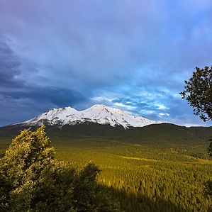
 It’s about 1.5 miles one way. The trail mostly utilizes an old Jeep trail, and makes its way up the south and east sides of the dome, switchbacking several times. Benches are placed at several vistas along the trail. One is treated to grand views of Mount Shasta in a number of places along the trail, as well as Black Butte to the north at one point. Once you reach the official end of the trail on the southwest side of the hill, you can see Mount Eddy, Castle Crags, and Lassen Peak. A couple of picnic tables are available at the top. About two thirds of the way up, there is a 0.4 mile Rocky Point Loop Trail, that also affords one an awesome view of Mount Shasta.
Check out the Official Route and Triplogs. Leave No Trace and +Add a Triplog after your hike to support this local community. | |||||||||||||||||||||||||||||||||||||||||||||||||||||||||||||||||||||||||||