username
X
password
register
for free!
help
 This is likely a great time to hike this trail!  Check out "Preferred" months below, keep in mind this is an estimate.
  

Heart Rock / Seeley Creek Trail 4W07, CA

Guide 2 Triplogs  0 Topics
  0 of 5  
Fav
Wish
1
details
drive
permit
forecast
route  
stats
photos
triplogs
topics
location
3 2 0
Statistics
tap row or icons for details
Difficulty 0.5 of 5
Distance One Way 0.47 miles
Trailhead Elevation 4,377 feet
Elevation Gain -250 feet
Kokopelli Seeds 0.89
unreported if dogs are allowed
editedit > ops > dogs to adjust
feature photo
Photos Viewed All MineFollowing
4  2022-10-11
Heart Rock Trail
fricknaley
3  2019-04-23 trailzrus
Author
author avatar Guides 16,843
Routes 17,472
Photos 24
Trips 1 map ( 6 miles )
Age 28 Male Gender
Location HAZ, TrailDEX
Associated Areas
list map done
Big Bear - Jacinto Region
Historical Weather
Trailhead Forecast
Radar Map
Expand Map
Preferred Sep, Jun, May, Oct
Sun  5:25am - 6:10pm
Official Route
 
0 Alternative


remove free decal offer

 Likely In-Season!
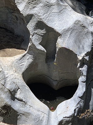
This short trail begins on Forest Service Road 2N03 - 1/4 mile south of the entrance to Camp Seeley on Highway 138. You must cross the creek. This easy hike follows Seeley Creek to an overlook called "Heart Rock" which marks the trail's end. Here there is a heart-shaped hole in the cliff next to a picturesque 20-foot waterfall. The gentle grade of this trail makes it an excellent walk for all ages, but be careful to watch out for the safety of children near the waterfall.


2019-06-24 HAZ_Hikebot


    Check out the Official Route and Triplogs.
    Leave No Trace and +Add a Triplog after your hike to support this local community.

    One-Way Notice
    This hike is listed as One-Way.

    When hiking several trails on a single "hike", log it with a generic name that describes the hike. Then link the trails traveled, check out the example.
    WARNING! Hiking and outdoor related sports can be dangerous. Be responsible and prepare for the trip. Study the area you are entering and plan accordingly. Dress for the current and unexpected weather changes. Take plenty of water. Never go alone. Make an itinerary with your plan(s), route(s), destination(s) and expected return time. Give your itinerary to trusted family and/or friends.

     Permit $$
    no fees or permits reported

    if incorrect tell us about it

    San Bernadino Forest
    Visit the San Bernadino Passes & Permits for current information


     Directions
    or
     Road


    To hike
    page created by joebartels on Jun 24 2019 4:24 am
     90+° 8am - 6pm kills
    helpcorrectionissue

    end of page marker