 Route Editor

| Guide | ♦ | 2 Triplogs | 0 Topics |
details | drive | permit | forecast | route |
stats |
photos | triplogs | topics | location |
| 37 | 2 | 0 |
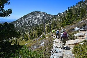
permanently saturated by DixieFlyer This is a connector trail that connects the Pacific Crest Trail (PCT) with Wellman Divide. Hike This trail branches off the PCT at Saddle Junction and goes north to Wellman Divide. The trail is very scenic, particularly if you are descending the trail since the views are in front of you -- there are really nice views of Palm Springs to the east and of mountains off to the south.
Water Sources Cienega is a Spanish word for spring. Wellman Cienega is a perpetual spring along the trail that is about 0.6 miles below Wellman Divide. At the spring you'll see lots of lush green growth. Check out the Official Route and Triplogs. Leave No Trace and +Add a Triplog after your hike to support this local community. One-Way Notice This hike is listed as One-Way. When hiking several trails on a single "hike", log it with a generic name that describes the hike. Then link the trails traveled, check out the example. | ||||||||||||||||||||||||||||||||||||||||||||||||||||||||||||||||||||||||||||||||||||||||||||||||


