 Route Editor

| Guide | ♦ | 1 Triplog | 0 Topics |
details | drive | permit | forecast | route |
stats |
photos | triplog | topics | location |
| 37 | 1 | 0 |
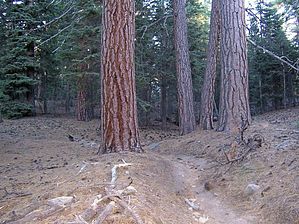
sweet n squishy by DixieFlyer This connector trail is part of the Pacific Crest Trail (PCT), which spans 2,650 miles from Mexico to Canada, and runs through 3 states: California, Oregon, and Washington. Hike This is a nice connector trail that runs from Saddle Junction on the east to Strawberry Junction on the west. There is really nice mountain scenery along the trail, with interesting rock outcroppings and lots of huge ponderosa pines and other coniferous trees.
Water is available at Strawberry Cienega. Cienega is a Spanish word for spring. Camping Just east of Strawberry Divide is the Strawberry Junction Campground. This campground has 3 campsites and a vault toilet. Check out the Official Route and Triplog. Leave No Trace and +Add a Triplog after your hike to support this local community. One-Way Notice This hike is listed as One-Way. When hiking several trails on a single "hike", log it with a generic name that describes the hike. Then link the trails traveled, check out the example. | |||||||||||||||||||||||||||||||||||||||||||||||||||||||||||||||||||||||||||||||||||||||||||||||||||


