username
X
password
register
for free!
help
 

Sherbrooke Lake Trail, BC

Guide 1 Triplog  0 Topics
  0 of 5  
Fav
Wish
0
details
drive
no permit
forecast
route  
stats
photos
triplog
topics
location
11 1 0
Statistics
tap row or icons for details
Difficulty 2 of 5
Distance One Way 2.79 miles
Trailhead Elevation 0 feet
Elevation Gain 721 feet
Accumulated Gain 742 feet
Kokopelli Seeds 5.26
unreported if dogs are allowed
editedit > ops > dogs to adjust
feature photo
Photos Viewed All MineFollowing
11  2019-07-15 gmaclachlan
Author
author avatar Guides 16,843
Routes 17,472
Photos 24
Trips 1 map ( 6 miles )
Age 28 Male Gender
Location HAZ, TrailDEX
Associated Areas
list map done
British Columbia Region
Historical Weather
Trailhead Forecast
Radar Map
Expand Map
Sun  5:03am - 6:25pm
Official Route
 
0 Alternative


remove free decal offer

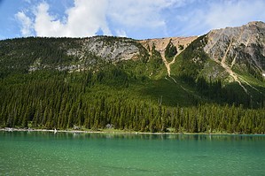
Sherbrooke Lake is a lake in Yoho National Park, British Columbia, Canada. The lake is bounded on the west by Mount Ogden 2,695 m (8,842 ft), Mount Niles 2,972 m (9,751 ft) to the north, and Paget Peak on the east side. The lake can be reached by following a three km hiking trail that begins from the Trans-Canada Highway across from Wapta Lake.


Source
Wikipedia


    Check out the Official Route and Triplog.
    Leave No Trace and +Add a Triplog after your hike to support this local community.

    One-Way Notice
    This hike is listed as One-Way.

    When hiking several trails on a single "hike", log it with a generic name that describes the hike. Then link the trails traveled, check out the example.
    WARNING! Hiking and outdoor related sports can be dangerous. Be responsible and prepare for the trip. Study the area you are entering and plan accordingly. Dress for the current and unexpected weather changes. Take plenty of water. Never go alone. Make an itinerary with your plan(s), route(s), destination(s) and expected return time. Give your itinerary to trusted family and/or friends.

     Permit $$
    no fees or permits reported

    if incorrect tell us about it


     Directions
    or
     Road


    To hike
    page created by joebartels on Jul 22 2019 4:04 pm
     90+° 8am - 6pm kills
    helpcorrectionissue

    end of page marker