The Squaw Springs Trail #038 is 4.1 miles long. The most commonly traveled direction is from Forest Road #071 (Geyser Pass) and to Forest Road #073 (Pack Creek-La Sal Pass).
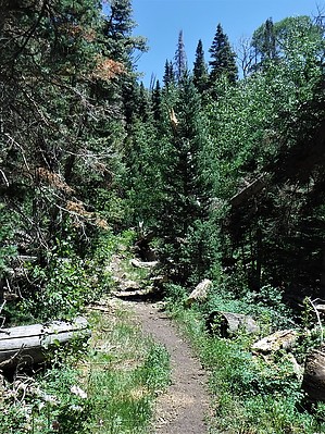
This trail traverses the face of the La Sals, crossing Brumley Creek and Dorry Canyon and Squaw Spring. It travels through aspen stands with outstanding views back towards Moab and Canyonlands National Park.
This popular trail sees use by multiple different types of users, primarily, hikers, mountain bikers and equestrian users. Please respect one another and observe standard trail etiquette: mountain bikers yield to both hikers and equestrian users and hikers yield to equestrian users.
When hiking several trails on a single "hike", log it with a generic name that describes the hike. Then link the trails traveled, check out the example.
WARNING! Hiking and outdoor related sports can be dangerous. Be responsible and prepare for the trip. Study the area you are entering and plan accordingly. Dress for the current and unexpected weather changes. Take plenty of water. Never go alone. Make an itinerary with your plan(s), route(s), destination(s) and expected return time. Give your itinerary to trusted family and/or friends.
Permit $$
no fees or permits reported
if incorrect tell us about it
Directions
Road
To hike From Moab, head south on US-191/Main St and travel 7.8 miles. Turn left onto Co Rd #127/Old Airport Rd (brown sign indicating Ken’s Lake and La Sals is located at the turn on US-191) and travel 0.6 miles. Turn right onto Co Rd #127/Forest Road #046 (La Sal Mountain Loop) and travel 11.5 miles. Turn right onto Forest Road #071 (Geyser Pass) and travel 3.0 miles to the trailhead on the right.
 Route Editor


