Route Editor

| Guide | ♦ | 4 Triplogs | 0 Topics |
details | drive | no permit | forecast | map |
stats |
photos | triplogs | topics | location |
| 51 | 4 | 0 |
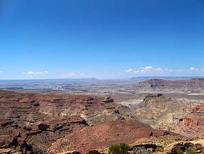
It's not the destination, its the trip by PaleoRob  The drive to the "trailhead" though is really the highlight. The road leaves Bigwater, Utah, and traverses a moonlike landscape of eroding Tropic Shale badlands. The Tropic was deposited during the Cretaceous period at the bottom of the inland sea, and numerous marine reptiles have been found within it.
After driving across the top of the mesa and taking the views, you eventually come to a series of cracks in the ground. This is where the active fires are located. Pull off the side of the road and begin hiking around. There isn't really a trail, just free-form exploration of the pits. You can tell the active ones when there is some smoke (occasionally) or the bad smell rising from the earth. Some places there are large mounds of rock on top of some of the fissures, where locals attempted to fill in the cracks and stop the fires. They were concerned the fires would eliminate all the coal deposits and they wouldn't be able to mine it. Fortunately, the entire area was made a National Monument by President Clinton, eliminating that prospect. From the pits, enjoy views south towards Navajo Mountain, east towards the Kaparowitz, and north towards the Aquarius Plateau. Once you have wandered at your leisure, return via the same route. As a warning, the road crosses three washes (Wahweap, Crosby, and Warm Creek) that can wash out during thunderstorms, leaving the unprepared motorist stranded. Take caution if storms are in the area, and do not attempt to cross a flowing wash. Check out the Triplogs. Leave No Trace and +Add a Triplog after your hike to support this local community. | ||||||||||||||||||||||||||||||||||||||||||||||||||||||||||||||||||||||||||||||||