Route Editor

| Guide | ♦ | 6 Triplogs | 0 Topics |
details | drive | no permit | forecast | route |
stats |
photos | triplogs | topics | location |
| 16 | 6 | 0 |
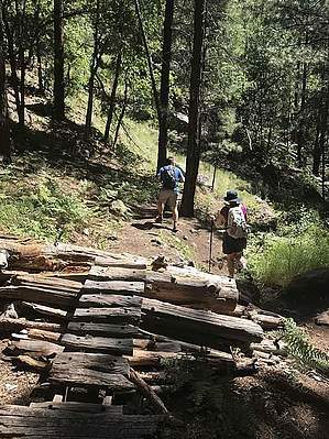
Mountainaire Coconino by Heliops  Kelly Pocket is a beautiful, relatively easy trail - and it is close to I-17 and just south of Flagstaff. The trail follows the canyon floor as it cuts through a lush ponderosa pine forest. After a mile and a half, Kelly Canyon proper enters from the left. Kelly Canyon will start to open up to large slabs of sandstone and beautiful rock cliffs from here. Around mile 3, the trail will leave the canyon floor and re-route you higher. It is well worth it to stay in the canyon and explore the various rock formations. At about 3.5 miles is the confluence of Kelly Canyon and Pumphouse Wash coming in from the right and left. Pumphouse Wash is a great place to explore or just have lunch. Turn around here for an out-and-back of about 7 miles. Kelly Pocket is a beautiful, relatively easy trail - and it is close to I-17 and just south of Flagstaff. The trail follows the canyon floor as it cuts through a lush ponderosa pine forest. After a mile and a half, Kelly Canyon proper enters from the left. Kelly Canyon will start to open up to large slabs of sandstone and beautiful rock cliffs from here. Around mile 3, the trail will leave the canyon floor and re-route you higher. It is well worth it to stay in the canyon and explore the various rock formations. At about 3.5 miles is the confluence of Kelly Canyon and Pumphouse Wash coming in from the right and left. Pumphouse Wash is a great place to explore or just have lunch. Turn around here for an out-and-back of about 7 miles.This trail was built by mountain bikers, so you will see ramps and jumps along the way. As a result, it is very popular with the mountain biking community, so pay attention and don't get run over! Despite this minor inconvenience, it is still well worth it to hike this beautiful part of AZ. Check out the Official Route and Triplogs. Leave No Trace and +Add a Triplog after your hike to support this local community. | |||||||||||||||||||||||||||||||||||||||||||||||||||||||||||||||||||||||||||||||||||||||||