Route Editor

| Guide | ♦ | 1 Triplog | 0 Topics |
details | drive | no permit | forecast | route |
stats |
photos | triplog | topics | location |
| 91 | 1 | 0 |
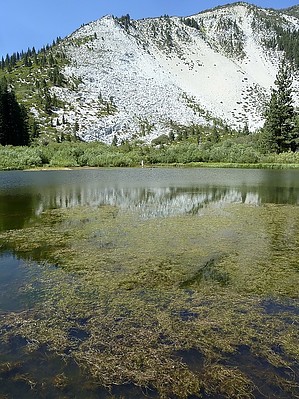
Picnic in the Shade B4 Returning by AZClaimjumper This is a hike up to Upper Price Lake that is well worth your time & effort. No bushwhacking required. Take a camera so you can record a variety of scenery. As usual, take a supply of water, nutrition, & gear in case Mother Nature changes the weather during your hike. There is no water at the Trailhead & the nearest portajohn is 1/4 mile beyond the trailhead.
Ophir Creek Trailhead/Parking Co ords: N39° 18.311' W119° 50.015' The first leg of your hike will be from the Trailhead up to Ophir Creek & is approximately 2.1 miles (6,085') which is a popular turn around/or & rest stop B4 proceeding on. Your accumulated elevation gain to this point is a little less than 1,000'. You have to walk through a 5' high gauntlet of big white rocks that is a narrow trail just B4 you arrive at Ophir Creek. You'll have two rudimentary log crossings to get across Ophir Creek, both of which are stable (see photos). When you see Trail Sign 2007 you'll know you're on track. Shortly beyond the sign you'll start up a rock chute with water flowing down the chute so watch your step, this is all part of the fun & games. You'll hike 0.5 miles after crossing Ophir Creek to reach the bottom of the rock chute. You'll gain almost 500' from the bottom to the top of the rock chute. Look to your right, you'll see glimpses of the upper Slide part of Slide Mtn. When you top out above the rock chute, you'll intersect with a trail junction (N39° 17.358' W119° 51.560'); one trail leads over to Rock Lake, the other trail leading up & Southwesterly to Price Lake. The trail is well-traveled/maintained & easy to stay on. From the trail junction/sign (6,624'elevation) you'll hike 1.5 miles & approximately 850' of accumulated elevation gain B4 coming to Upper Price Lake (see photos) where there are picnic tables & shade. Turn left (N39° 17.556' W119° 52.409'), off the road & take the trail which parallels a ditch carrying water to Franktown. This trail is THE ONLY way to hike into Upper Price Lake. I was absolutely in awe of the lake/mountain scenery (see photos). There are numerous places all along the entire hike for MEeee to filter water from sources into the water reservoir inside my backpack. No need to carry more than 16 oz anywhere along this hike if you have the equipment for filtering water from the nearby water sources. Check out the Official Route and Triplog. Leave No Trace and +Add a Triplog after your hike to support this local community. | ||||||||||||||||||||||||||||||||||||||||||||||||||||||||||||||||||||||||||||||||||||||||||||||||