 Route Editor

| Guide | ♦ | 8 Triplogs | 0 Topics |
details | drive | no permit | forecast | route |
stats |
photos | triplogs | topics | location |
| 17 | 8 | 0 |
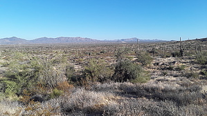
Bursting with Hairpins by DarthStiller   The Cloudburst Trail is a newly built trail that has recently appeared in the new Scottsdale Sonoran Preserve maps dated September 2019. The quickest way to get to it is from the Brown's Ranch Trailhead taking the Upper Ranch and Cone Mountain Trails. The southern end of the Cloudburst Trail junctions the Cone Mountain Trail directly north of Cone Mountain, nearly directly north of the peak of Cone Mountain. The Cloudburst Trail is a newly built trail that has recently appeared in the new Scottsdale Sonoran Preserve maps dated September 2019. The quickest way to get to it is from the Brown's Ranch Trailhead taking the Upper Ranch and Cone Mountain Trails. The southern end of the Cloudburst Trail junctions the Cone Mountain Trail directly north of Cone Mountain, nearly directly north of the peak of Cone Mountain.The trail trends in a northwesterly direction, with several hairpin bends along the way. The southern end of it has a few banked bends, so this trail appears in some ways to cater more to the mountain bikers who frequent this area. Within a half-mile, however, the trail tends to level out more, although the hairpins continue to the end, at the junction with the Hawknest Trail.
Vegetation is the typical sonoran desert flora: saguaros, paloverdes, cholla, sagebrush. At one point towards the north end the trail threads between about 4 saguaros.
Check out the Official Route and Triplogs. Leave No Trace and +Add a Triplog after your hike to support this local community. One-Way Notice This hike is listed as One-Way. When hiking several trails on a single "hike", log it with a generic name that describes the hike. Then link the trails traveled, check out the example. | |||||||||||||||||||||||||||||||||||||||||||||||||||||||||||||||||||||||||||||||


