 Route Editor

| Guide | ♦ | 4 Triplogs | 0 Topics |
details | drive | no permit | forecast | route |
stats |
photos | triplogs | topics | location |
| 14 | 4 | 0 |
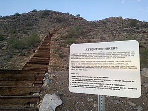
Verrado's Stepchild by mt98dew  Notice NoticeTrails are provided for the enjoyment of Verrado residents and their guests only. - source Overview Verrado has been a burgeoning community for the last 10 years. However, their proclaimed forthcoming trail system has been stagnant. Verrado has finally made good on creating a short but credible trail for the hiking aficionado. The trail is as of yet not signed, though it is easy enough to follow. And as of yet does not have an official name (that I know of), but locals have dubbed it Victory Staircase. Once a person sees the trail, its name is obvious; the first 0.15 miles is composed of railroad ties that form steps up the side of a hill. The rest of the trail is composed of compact dirt and thoughtfully designed stoned steps that form an upper or lower loop option. This trail is very similar to Sunrise and West Wing Trails (only smaller) in that it is an isolated, self-contained system.
The trail begins by climbing over 300 steps made of railroad ties that gain you a little over 200ft to start the hike. Just before the end of the railroad ties, a trail heads off to the south that offers the first loop option. You can easily miss this since it is not signed, and most eyes are focused on the ending of the steps. Where the railroad ties end, a dirt trail interacts with the 3 hills that compose this system. From the ties, that dirt trail continues to climb, switchbacking up the east side of the hill. You gain about another 150 ft to get to the top of the hill. Along the way, there are several nice platforms to look off toward the east. From my limited experience, most hikers turn around at the ties or the top of this hill. The top of the hill is the high elevation point for this trail. However, the trail does continue. The trail follows a saddle towards a taller peak. About 0.35 miles in, there is a branch in the trail. One trail holds its elevation, going along the slope of this taller peak, but it never tempts to climb it. The other trail begins a gradual descent as it works along the eastern side of a smaller hill. Both trails end up reconnecting, so it doesn't matter which branch you take. The higher trail is about 0.3 miles (before reconnecting) and circles around the hill's western side. The aforementioned lower trail is a little more direct, being only 0.2 miles before reconnecting. Where these trails reconnect, a third branch drops down below these two and, after doing some minor switchbacking, heads in a north-south direction. This trail has some ups and downs as it negotiates the slopes of the hill and eventually connects to the railroad ties. This segment is only 0.4 miles long. All these trails interconnect, offering several loop options. None of which are of great length. If one were to do all the trails (loops) in this system, it would total 1.6 miles approximately. Water Sources There are no restrooms or water sources at this TH, so come prepared. And though the trail is not lengthy, there is some decent elevation gain.
Check out the Official Route and Triplogs. Leave No Trace and +Add a Triplog after your hike to support this local community. One-Way Notice This hike is listed as One-Way. When hiking several trails on a single "hike", log it with a generic name that describes the hike. Then link the trails traveled, check out the example. | ||||||||||||||||||||||||||||||||||||||||||||||||||||||||||||||||||||||||||||


