 Route Editor

| Guide | ♦ | 22 Triplogs | 0 Topics |
details | drive | no permit | forecast | 🔥 route |
stats |
photos | triplogs | topics | location |
| 0 | 22 | 0 |
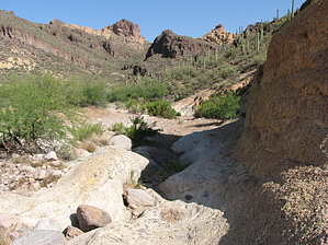
Call it what you want by markthurman53  Overview OverviewCottonwood Wash is one of the three main north-south running washes in the central Goldfield Mountains, the other two being the Rough N Ready Canyon and Willow Springs Canyon. The Cottonwood and Rough N Ready both end up draining into Willow Springs Canyon. This wash is not as impressive as willow Springs Canyon or the Rough N Ready Canyon, but I found it to be a component of most of the loop hikes I have done in the central Goldfield Mountains. The upper portion of the wash is just your run of the mill desert wash, but the further in you go, the more interesting it gets. It never really turns into what I would call a canyon, but the rock formations that it passes through are quite impressive. Most of the route is in the bed of the creek, with no trail or road. Cottonwood Wash starts at the junction of FR 1356 and FR 3512 Pack Saddle Road and ends where Cottonwood wash joins the Rough N Ready Canyon and trail. This description follows the route along Cottonwood Wash. FR 3512 Pack Saddle 4WD Road comes in from the south From the Hackamore Trailhead and eventually drops down into the Cottonwood upper watershed. It then follows alongside Cottonwood Wash until it drops into the wash near Cottonwood Spring, so Cottonwood Wash is also called the Pack Saddle Trail. The upper portion of Cottonwood Creek from FR1356 to the spring is also called the Cottonwood Spring Trail. For simplicity, I have the Pack Saddle trail ending where the road enters Cottonwood Creek near Cottonwood Spring, and the route/Trail along the wash is the Cottonwood Wash Trail.
The Cottonwood Wash route starts at the junction of FR 1356, east end Rock House Trail and FR 3512 Pack Saddle 4WD Road. For this description, I followed the wash. The first 0.6 miles to Cottonwood Spring is an easy walk along a wash, nothing too impressive. At about 0.4 miles, a couple of ravines come in from the west. This is where one of the routes to Top Hat Peak exits the wash. 0.2 miles further downstream is Cottonwood Spring. The agave plants growing near the spring attest to the presence of earlier inhabitants, Ranching/mining? The Pack Saddle Road can be taken to this point instead of the wash, but I found the wash easier. The road stays higher up on the West side of the creek and goes up and down a couple of ravines. Continuing down the wash at about 0.3 miles from the spring, the south entrance to the Horse With No Name Trail exits west. The wash makes a bend to the northeast, and after 0.5 miles, the Frankie Goes To Hollywood Trail enters from the south. The wash along this section has no major obstacles and is relatively easy to navigate. Occasionally FR 3512 will run alongside the wash in this section. The scenery on either side of the wash becomes more interesting along this stretch. It is a reasonably wide wash with fantastic rock formations on either side. After the Frankie Goes To Hollywood Trail the wash makes a turn to the north, and two connector trails exit to the east within a tenth of a mile of each other and head up to a low ridge of rocks that leads to the Anniversary Arch Loop. Knowing their approximate location helps in locating them, very scenic side trip. Continuing north in the wash 0.4 miles from the Frankie Goes To Hollywood Trail is the north end of the Horse With No Name Trail. Another 0.4 miles, and the wash makes a sharp turn back to the east. Just before this turn, the route to Camouflage Tanks and Pedestal Arch exits to the west. The last 0.5 miles of Cottonwood Wash has the only section that might qualify as calling this a canyon. The wash runs up against a high rock cliff on the north side for a short stretch, then opens up again before the Rough N Ready Canyon junction. Whether you walk in the wash and call this the Cottonwood Wash Route or along the intermittent stretches of FR 3512 and call it part of the Pack Saddle Trail, Cottonwood Wash is easy to navigate. Check out the Official Route and Triplogs. Leave No Trace and +Add a Triplog after your hike to support this local community. One-Way Notice This hike is listed as One-Way. When hiking several trails on a single "hike", log it with a generic name that describes the hike. Then link the trails traveled, check out the example. | |||||||||||||||||||||||||||||||||||||||||||||||||||||||||||||||||||||||||||||||||||||||||||||||||||||||||||||||||||||||||||||||||||||||||||||||||||||||||||||||||||||||||||||||||||||||||||||||||||||||||||||


