username
X
password
register
for free!
help
  
   🔥

Frankie Goes to Hollywood, AZ

Guide 16 Triplogs  0 Topics
  3 of 5  
Fav
Wish
0
details
drive
permit
forecast
🔥
route  
stats
photos
triplogs
topics
location
6 16 0
Statistics
tap row or icons for details
Distance One Way 1.6 miles
Trailhead Elevation 2,313 feet
Elevation Gain -200 feet
Accumulated Gain 85 feet
Avg Time One Way 1 hour
Kokopelli Seeds 1.88
 Interest Seasonal Creek
 Backpack No
feature photo
Photos Viewed All MineFollowing
Inaugural Calculation on Button Tap!
23  2025-01-26
Goldfield Canyons and Arches
DesertNymph
23  2025-01-26
Horse with No Name Trail
Vashti
6  2024-06-15
Rough Eye Javelina Loop
ddgrunning
13  2024-03-27
Goldfields figure 8
trekkin_gecko
14  2024-03-27
Goldfields figure 8
johnlp
27  2024-02-15
Overlook Arch - Goldfields
LindaAnn
26  2024-02-15
Overlook Arch - Goldfields
joebartels
15  2024-02-15
Overlook Arch - Goldfields
The_Eagle
Page 1,  2
Author
author avatar Guides 187
Routes 990
Photos 12,079
Trips 865 map ( 6,885 miles )
Age 72 Male Gender
Location Tucson, Arizona
Associated Areas
list map done
Phoenix Region
Historical Weather
Trailhead Forecast
Radar Map
Expand Map
Preferred Jan, Dec, Feb, Nov
Seasons   Late Autumn to Early Spring
Sun  6:03am - 6:45pm
Official Route
 
13 Alternative
 
Historic Fire Perimetersacres
🔥 Gost 20055.4 mi*
🔥 2005 Ghost5.4 mi*
🔥 View (All) - over Official Route 🔥
*perimeter length in miles


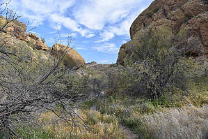
Who the heck is Frankie
by markthurman53

  
Overview
I don’t know who Frankie is and this trail doesn’t go to Hollywood. Strange name for a trail but it does have value as a connector trail, a means of getting to some destination as long as it isn’t Hollywood. This trail starts along FR1356 about 1.3 miles from the Cottonwood Trailhead. If you have a Bulldog Canyon Recreational Pass, see permits, you can drive to the Frankie, otherwise park at the Cottonwood Trailhead, and walk the 1.3 miles.


This trail heads north and follows an unnamed wash for 1.6 miles where it ends at Cottonwood Wash. At a quarter-mile in, Willow Connector Trail enters from the east. The Frankie Goes To Hollywood Trail and the Willow Connector make for some more challenging loop hikes. This trail is also one of the more direct routes to get to central Cottonwood Wash.
remove free decal offer
Description
From the Cottonwood Trailhead, FR 1356 at 1.3 miles in it crosses a small wash 3 times within a hundred yards, park anywhere alongside the road. Head downstream following the wash. There will be signs of a trail off and on but when in doubt follow the wash. At a quarter-mile in, the Willow Connector Trail comes in from the east and the trail becomes easy to see and follow. This portion of the trail appears to be used quite a bit by horses. The trail follows alongside the wash and sometimes in the wash. Watch for the trail exiting the wash. I had no problem locating these exits. The scenery so far is pretty nondescript, with low-lying hills in a U-shaped valley. At 1 mile in the scenery changes, the canyon gets narrower and the trail follows the creek bed as the creek passes through some rock outcrops. Nothing exciting but it is different. Just before the creek enters the narrows if you look up in the rocks to the northwest about halfway up the hill there is a small arch. When I reviewed this in my pictures though it looks more like a rock that fell and formed an arch. At 1.3 miles in the trail exits the creek for the last time to the west. 0.3 miles later the trail ends in Cottonwood Wash.

2020-02-23 markthurman53


    Check out the Official Route and Triplogs.
    Leave No Trace and +Add a Triplog after your hike to support this local community.

    One-Way Notice
    This hike is listed as One-Way.

    When hiking several trails on a single "hike", log it with a generic name that describes the hike. Then link the trails traveled, check out the example.
    WARNING! Hiking and outdoor related sports can be dangerous. Be responsible and prepare for the trip. Study the area you are entering and plan accordingly. Dress for the current and unexpected weather changes. Take plenty of water. Never go alone. Make an itinerary with your plan(s), route(s), destination(s) and expected return time. Give your itinerary to trusted family and/or friends.

     Permit $$
    Bulldog Canyon OHV permit
    The permit is free, but a $6 processing fee is required to obtain from www.recreation.gov (tap get permit)
    The permit is good for 6 months. Upon purchase, you'll be given the gate codes to get through the gate.
    Warning
    FR1356 is sandy in some sections and is a bit rocky in other sections, so a 4WD vehicle will be needed to drive this road.


     Directions
    or
     Road
    Strictly 4x4

    To Cottonwood - Bulldog OHV Trailhead
    This Trailhead is part of the BullDog Canyon OHV area and an administrative permit can be obtained at no cost from the Mesa Tonto Forest Office, see permits. The permit is only needed for driving beyond the gate for those with a four wheel drive vehicle.

    From the Apache trail AZ-88 & Idaho Road in Apache Junction go 6.1 miles northeast, one quarter mile past milepost 202 on a blind corner watch for a dirt road on the left. This is the trailhead. No facilities and parking for a dozen cars.

    From PHX (I-10 & AZ-51) 43 min (40.9 miles)
    From TUC (Jct 1-10 & Grant) 1 h 54 min (111 miles)
    From FLG (Jct I-17 & I-40) 2 h 51 min (182 miles)
    page created by markthurman53 on Feb 23 2020 8:41 pm
     90+° 8am - 6pm kills
    helpcorrectionissue

    end of page marker