 Route Editor

| Guide | ♦ | 1 Triplog | 0 Topics |
details | drive | permit | forecast | route |
stats |
photos | triplog | topics | location |
| 0 | 1 | 0 |
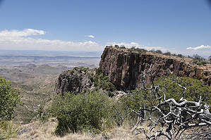
Views second only to Emory Peak by markthurman53  The Rio Grande River comes down out of Colorado heads south through New Mexico and passes through El Paso Texas where it now becomes the border between the United States and Mexico. The river flows 1254 miles in a South East direction toward the Gulf of Mexico but before getting there it makes a turn to the North East, creating a momentary bend in the river, This Is Big Bend National Park. The mountains in this park are a continuation of a mountain range in Mexico which will continue up into the US through Guadalupe National Park and into New Mexico. The highest Point in this park is Emory Peak at 7800 feet. This park is probably one of the remotest parks in the contiguous United States but despite being in the middle of nowhere has a lot to offer in hiking, camping and general sightseeing. SOUTH RIM TRAIL
To the south of Emory Peak is a relatively flat area with an elevation of about 7000 feet surrounded by high cliffs on the east, south and west sides. The South and East Rim Trails follow along this rim. The Park Labels them as the South and East Rim Trails but I have seen them called the West, Northeast and Southeast Rim Trails also. Access to this Trail is not direct and must be done in combination of other trails, Laguna Meadow, Blue Creek or Pinnacles Trail. These are fairly level trails changing only a couple hundred feet over their course. This area is through mainly Juniper and Oak forests. Views along the rim are spectacular and in slightly different directions depending on which rim you are on. The rim trails make for a good extended loop hike from Chisos Basin, either a day hike (for the veteran hikers) or an overnight if not wanting to do the 17 miles in one day. Be prepared to bring all water you will require because water in the Chisos Mountains is not always available The eastern-most portion of the East Rim Trail is closed Feb 1 - May 31 for peregrine falcon nesting. Contact Big Bend National Park at (432) 477-2251 with any questions regarding the closure. Description The South Rim Trail has its end points at the junction with the Laguna Meadows and Colima Trails in the north and the Boot Canyon and East Rim Trails in the south. From the Laguna Meadows junction the South Rim Trail continues to climb 250 feet to the high point along the west rim. During the first half mile most of this elevation is gained as you ascend the west facing rim. There are great views of this rim from this portion of the trail. Because a little over half this trail follows above the west rim this trail has been called the west Rim Trail by some but the trail doesn’t really get up close to the rim until it is along the South Rim section. The trail along the west rim is fairly level losing then gaining 100 feet of elevation over a 1 mile stretch. There are not a lot of views from this section of trail because you are back from the rim and in a pinion pine forest. At the end of this mile stretch the trail drops almost 300 feet and you are now on the south facing rim. Before you descend take a side trip to the west to an overlook. This little diversion is about 0.2 miles off the South Rim Trail along a side trail to an overlook; the views from this point are worth the trip. This point is also the area where the south facing rim heads north to become the west facing rim. Once back on the trail descend the 300 feet, the trail remains close to the rim for the next half mile to its terminus at the Boot Canyon and East Rim Trails. The views along this trail are excellent especially to the south into Mexico. The trails are well maintained and signed. There are campsites along the South Rim Trail and one restroom, bear boxes are also available. Check out the Official Route and Triplog. Leave No Trace and +Add a Triplog after your hike to support this local community. One-Way Notice This hike is listed as One-Way. When hiking several trails on a single "hike", log it with a generic name that describes the hike. Then link the trails traveled, check out the example. | ||||||||||||||||||||||||||||||||||||||||||||||||||||||||||||||||||||||||||||||||||||||


