 Route Editor

| Guide | ♦ | 27 Triplogs | 0 Topics |
details | drive | no permit | forecast | route |
stats |
photos | triplogs | topics | location |
| 53 | 27 | 0 |
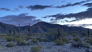
Cholla Plano by LindaAnn  Overview OverviewEasy, short loop with minimal elevation gain. Getting there From the Pyramid Trailhead, take Pyramid Trail about 3/4 mile to the start of the Cholla Flats Loop Trail. You will cross a large dry wash on Pyramid immediately before the start of Cholla Flats, which is signed. Hike The loop can be done in either direction, but this description describes it counter-clockwise. The trail begins by heading south, paralleling the wash you just crossed. As you near the neighborhood ahead of you, the trail will turn east. The walk to the east is easy, and the trail skirts the southern boundary of the park. You will cross a few dry washes, and these account for most of the elevation change on this part of the trail.
The loop itself is 2.65 miles with 248' aeg. Getting to and from the Pyramid trailhead (closest trailhead) adds another 1.60 miles and 125' aeg to the hike, for 4.25 miles and 375' aeg. Casual hikers, trail runners, and mountain bikers will likely get the most use out of this loop, but it also adds the option to cut off a big chunk of the road walk between Pyramid and Foothills (Telegraph Pass) trailheads.
Check out the Official Route and Triplogs. Leave No Trace and +Add a Triplog after your hike to support this local community. One-Way Notice This hike is listed as One-Way. When hiking several trails on a single "hike", log it with a generic name that describes the hike. Then link the trails traveled, check out the example. | |||||||||||||||||||||||||||||||||||||||||||||||||||||||||||||||||||||||||||||||||||||||||||||||||||||||||||||||||||||||||||||||||||||||||||||||||||||||||||||||||||||||||||||||||||||||||


