 Route Editor

| Guide | ♦ | 1 Triplog | 0 Topics |
details | drive | no permit | forecast | route |
stats |
photos | triplog | topics | location |
| 38 | 1 | 0 |
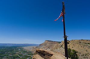
 This hike starts next to an active highway (I-70)! There is limited shoulder parking and obvious risks associated. There is also not really any shade and no water along this route that winds its way up 1,000 feet vertically into the Bookcliffs. Be prepared, and maybe think about doing this as a shuttle or as part of another route instead. Overview Before the railroad came into the Grand Valley in 1888, wagons and stagecoaches were used to haul people and goods in and out of the area. The main route in dropped down the mouth of DeBeque Canyon where the Grand Valley begins, in Palisade. This hike follows a portion of the old stagecoach route to a flagpole that overlooks Palisade and the Grand Valley.
The hike starts at an unmarked pullout just past the Colorado River along westbound I-70. This is currently the only legal access to this trail from the east side. Once safely off onto the shoulder (but not into the rough, uneven ground past it), your hike begins. Cross the cheatgrass field to find the trail that is in regular use from the illegal railroad crossing access, below the highway bridge. Once you've located this trail, the real fun begins. Turn left and follow the well-used trail as it starts to head upwards. There are several branching paths to take here, but they all lead essentially to the same location. Choose one of them to get off the flatter path and begin ascending. All the options are going to be rough and steep, with frequent switchbacks, until you reach another well-used trail leading to the left. Follow this until it intercepts what appears to be an old road. This is actually the original stagecoach route! Turn right and continue uphill on the stagecoach path. Those folks must have had a lot of strong horses to get things up the grade, though I'm sure it has eroded significantly since it was last used. The route is rocky and exposed, with the elevation quickly mounting. Near the top, the route bends away from the highway and there is a nice view of the low-head dam that diverts irrigation water into a tunnel that actually passes deep underneath the trail and brings water to crops in the western part of the Grand Valley. It is also at this point where you can see the notch blasted through the capping sandstone to allow the stage route to pass through. You'll head up through there. Once past the notch, the trail can seem indistinct. Stay straight, climbing up over the next couple of sandstone ledges as the trail through the pinyon-juniper forest resumes. If you do turn left there are numerous false trails and cairns - these may mislead folks, but if you get lost (or go that way on purpose) it is easy to find your way. From the flats, the flagpole stands out on a knoll on the horizon. If you begin hiking in that direction, you'll encounter the true trail soon enough. The trail itself from the notch across the flats is well-defined and easy to follow. Mt. Lincoln towers above and on nice days you will probably hear gunfire from the Cameo shooting range, on the other side of the ridge to your right and down in a canyon. Eventually, the trail hits the rim of the Bookcliffs and starts climbing again. At this point, you're treated to some neat views of Palisade as well as decent coal deposits as you begin gaining altitude again. Circling past the head of a drainage, the trail becomes indistinct at times. Keep heading generally towards the canyon and hugging the right side of the off-the-rim drainage, and you should be fine. The trail can also be seen climbing towards the flagpole, up the ridge ahead and to the right. Keeping that in mind, it is easy to stick to the trail. The final ascent is just as steep as the first but shorter. Once at the flagpole enjoy the views which stretch across a huge chunk of western Colorado. Continue along the trail to intersect the Lemon Squeeze/Mt. Lincoln trails, or return the way you came. Water Sources None. Bring your own. Camping Possible. There are several nice spots along the rim. Note Again, this is the only legal access to this trail from the east. Many other guides suggest parking at the Palisade boat ramp and trespassing along the railroad right away. There are multiple signs warning against this in the area. There used to be a second, more secluded highway pullout but this now has no parking signs posted. The pullout just past the Colorado River is currently the only east-side access. Check out the Official Route and Triplog. Leave No Trace and +Add a Triplog after your hike to support this local community. One-Way Notice This hike is listed as One-Way. When hiking several trails on a single "hike", log it with a generic name that describes the hike. Then link the trails traveled, check out the example. | |||||||||||||||||||||||||||||||||||||||||||||||||||||||||||||||||||||||||||||||||||||


