username
X
password
register
for free!
help
 

Snook's Bottom, CO

Guide 3 Triplogs  0 Topics
  2 of 5  
Fav
Wish
0
details
drive
no permit
forecast
route  
stats
photo
triplogs
topics
location
1 3 0
Statistics
tap row or icons for details
Difficulty 0.5 of 5
Route Finding 1 of 5
Distance Lasso-Loop 1.1 miles
Trailhead Elevation 4,496 feet
Elevation Gain -33 feet
Accumulated Gain 27 feet
Avg Time Round Trip 1 hour
Kokopelli Seeds 1.24
 Backpack No
feature photo
Photos Viewed All MineFollowing
1  2020-04-23 PaleoRob
Author
author avatar Guides 171
Routes 253
Photos 6,100
Trips 1,135 map ( 2,556 miles )
Age 44 Male Gender
Location Pocatello, ID
Associated Areas
list map done
Northwest Region
Historical Weather
Trailhead Forecast
Radar Map
Expand Map
Preferred Oct, Apr, May, Mar
Seasons   Spring to Autumn
Sun  5:47am - 6:40pm
Official Route & 2 Rts
 
0 Alternative


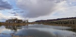
A quick way to move your bottom
by PaleoRob

Overview
This quick hike circles a pond named for early Fruita resident Billy Snook, who had something of a colorful life (shot a horse thief, multiple wives, etc.). This trail is quick and easy for visitors and locals alike.


Hike
The hike starts at the parking area and descends a slight hill to a fork. The counter-clockwise loop is paved for the first half, making it wheelchair accessible. There is also a fishing dock and folks will often be seen casting throughout the spring and summer. A portable toilet sits at the base of the parking lot hill as well, providing the only restroom in the hiking area.
remove free decal offer
The trail itself is uncomplicated and easy to follow. The south side of the trail is not paved and can be muddy after rains, so avoid it when it is wet. The Morrison Formation, which makes up Opal Hill to the south (also accessible from the same trailhead) turns to nasty, sticky clay when wet. If you can avoid walking through wet Morrison you definitely should.

Camping
Not allowed.

Note
As of this writing, swimming is not allowed but human-powered watercraft are allowed on the lake. There is also a disc golf course that is accessible from this point if you are interested in that.

2020-05-11 PaleoRob


    Check out the Official Route and Triplogs.
    Leave No Trace and +Add a Triplog after your hike to support this local community.
    WARNING! Hiking and outdoor related sports can be dangerous. Be responsible and prepare for the trip. Study the area you are entering and plan accordingly. Dress for the current and unexpected weather changes. Take plenty of water. Never go alone. Make an itinerary with your plan(s), route(s), destination(s) and expected return time. Give your itinerary to trusted family and/or friends.

     Permit $$
    None


     Directions
    or
     Road
    FR / Dirt Road / Gravel - Car Okay

    To hike
    From Fruita, head south on CO-340. Cross the Colorado River and make a right onto King's View Road. Follow this road through the small neighborhood. At a sharp left turn, the pavement ends and there is an intersection. Turn right at this intersection and follow the good gravel road to the parking lot at the end.
    page created by PaleoRob on May 11 2020 9:45 pm
     90+° 8am - 6pm kills
    helpcorrectionissue

    end of page marker