Route Editor

| Guide | ♦ | 1 Triplog | 0 Topics |
details | drive | permit | forecast | route |
stats |
photos | triplog | topics | location |
| 0 | 1 | 0 |
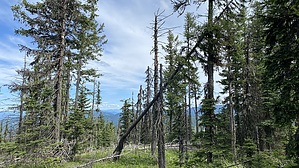
glimpses of the valley below by LindaAnn At approx 1 mile, there will be a fiberglass mile marker sign (1) on the left side of the road, and a small trail turning left. Take this trail west, then north as it climbs up the south side of Peak 4872. Continue on this OHV trail for about a third of a mile until you reach an obvious clearing on your left. From here, the OHV trail veers right, but at the north end of the clearing, a faint game/use trail continues north and uphill. Follow this trail uphill as best you can, eventually turning west and up to the summit. It's generally easy off-trail with a few downed trees to climb over, and none of the vegetation seems to have thorns. As you reach the summit, there are some rocks and what looks to be an old fire ring. Views are limited due to the trees. A little walking around gets you glimpses of the valley below.
Gate Policy: If a gate is closed upon arrival, leave it closed after you go through. If it is open, leave it open. Leaving a closed gate open may put cattle in danger. Closing an open gate may cut them off from water. Please be respectful, leave gates as found. The exception is signage on the gate directing you otherwise. Check out the Official Route and Triplog. Leave No Trace and +Add a Triplog after your hike to support this local community. | ||||||||||||||||||||||||||||||||||||||||||||||||||||||||||||||||||||||||||||||||||||||