 Route Editor

| Guide | 0 Triplogs | 0 Topics |
details | drive | no permit | forecast | 🔥 route |
stats |
photos | triplogs | topics | location |
| 10 | 0 | 0 |
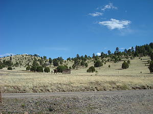
land in middle fork by BrettVet  The trail itself climbs immediately to a saddle between the rolling hills to the east of Lilly Mountain revealing a panoramic view of the vastness of the Gila. The Middle Fork canyon scars the landscape and is our destination. Aerorplane Mesa is a vast meadow that stretches 5 miles to the edge of the middle fork canyon. It got its name from an early airmail pilot that crashed his plane here. He survived, but his plane did not. The walk out must have been a bitch! The trail traverses the meadow, sometimes a well graded trail with some rocky rubble to a sometimes cow path wandering aimlessly. A cowboy stopped by our campsite and asked us to close the fence gait half way across the mesa. Nice but tough character and I was glad that my revolver had more bullets than his mouth had teeth. Visions of the movie Deliverance played with my mind.
Trotter Meadow is a good base camp to explore this section of the Gila , because many trails intersect here. It allows access up and down the middle fork , clear creek and the Jerky mountains and several canyon hikes. The first day we hiked down the Gila about 4 miles and turned around. The next day we hiked up out the Middle Fork canyon on the Trotter trail to Clear Creek. Nice destination with a backpack because there is year round water there and allows access to the back side of the Jerky Mountains. The last day we went up the middle fork to the ruins (pile of rocks) near Snow Lake. Check out the Official Route. Leave No Trace and +Add a Triplog after your hike to support this local community. One-Way Notice This hike is listed as One-Way. When hiking several trails on a single "hike", log it with a generic name that describes the hike. Then link the trails traveled, check out the example. | |||||||||||||||||||||||||||||||||||||||||||||||||||||||||||||||||||||||||||||||||||||||||||||||||||||||||||||||||||||||


