Route Editor

| Guide | ♦ | 1 Triplog | 1 Topic |
details | drive | no permit | forecast | 🔥 route |
stats |
photos | triplog | topic | location |
| 15 | 1 | 1 |
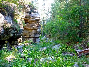
Tiptoe Through the Coneflower by kingsnake   Prologue PrologueIt wasn't until I got home from hiking the upper part of Miller Canyon that I realized my previous guide was only for the middle portion, not the whole thing. I consulted with Joe, and he left it up to me whether I wished to do extensive edits on middle Miller or create a new guide for upper. So, here we are! Overview Miller Canyon is a 14-mile canyon that flows downhill, north from the Mogollon Rim at Hi View Point to East Clear Creek, just downstream from C.C. Craigan Reservoir. Miller Canyon is bounded by Miller Ridge, Blazed Ridge, McCarty Ridge, and Battleground Ridge. FR 141H separates the 3.5-mile upper section from the middle section, while the junction with East Miller Canyon, separates the middle from the lower 6.0 miles.
There is no pull-off spot on Rim Rd at Miller Canyon, but there are a couple of worthy places just up FR 320 from Rim Rd. Hike From where you parked, head towards Immigrant Spring, which is just over ⅓ mile from FR 320, at the bottom of Miller Canyon. From there, head north. North of Immigrant Spring, upper Miller Canyon immediately becomes slower travel. Not tricky, or obstacle-filled, but not a highway either. That comes later. The vegetation was bracken fern and corn lily, with no grab & stabs. Coneflower was by far the most common flower, though there was also plenty of Richardson’s Geranium and a scattering of other species. After dodging a few minor obstacles, the 1¼ miles north of Immigrant Spring, upper Miller Canyon opens up quite a bit: Not a prairie, nor a cienega, but grassy & reasonably wide, with an animal trail that you can follow most of the next two miles to FR 141H. FR 141H is at the four-mile mark of the Upper Miller Canyon hike, or 3½ miles north of Immigrant Spring. Either cross north, over the forest road, and begin middle Miller Canyon, head back the way you came, follow the gaggle of jeep trails on the west side of the canyon back to the trailhead, or follow FR 141H and FR 320 back to the trailhead. (Mileage and stats for the latter option.) Check out the Official Route and Triplog. Leave No Trace and +Add a Triplog after your hike to support this local community. | |||||||||||||||||||||||||||||||||||||||||||||||||||||||||||||||||||||||||||||||||||||||||||||||||||||