Route Editor

| Guide | ♦ | 13 Triplogs | 0 Topics |
details | drive | no permit | forecast | route |
stats |
photos | triplogs | topics | location |
| 59 | 13 | 0 |
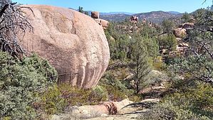
Payson's Crème de La Crème by donqcryer  Overview OverviewStewart Pocket in Payson has some of the best trails in Rim Country and rightful so. Most trails have shade from pine, cypress, old large scrub oak, and abundant Manzanita trees. Add towering pink-rock-formations from massive boulders and balanced rocks, many covered in blue turquoise lichens, nestled below Stewart ridge to the south. Throw in the glorious scenic Mogollon Rim to the north, seasonal streams, and good wildlife. What's not to Love? Details This trail (I hiked, but great for mountain biking) is the crème de la crème of Payson Trails. Parts of the trail have been hidden for some time (why some think the parts of the National Forest can be kept private and secret is beyond me!). The 'hidden' section is a 2-mile well-constructed trail made by the mountain biking gnomes in the area with bridges, fancy metal mileage markers, and even a beautiful bench along the way. Most of the trail is "unofficial" (built over the years, section by section, by our industrious gnomes...) but returns on PAT Boulders South and Cypress Trails. It is about 7 miles in length, upside down, with about 800' of altitude gain. The views and attractions are nothing short of spectacular! BTW, there are now mean looking steers with scary-looking pointed longhorns in this whole area - but fear not, they are innocent cows and more scared of you and harmless.
The Trail starts at the end of Phoenix Street, where most Stewart Pocket trails begin. It begins on the PAT Cypress spur trail, but within 500' ish before the 2nd wash, you turn right on the unofficial HA Stewart Pocket Trail (aka Trail 200). My GPS route takes the quickest way to the hidden extension part of this Circle, taking the lower / north part of the Stewart Pocket Loop, then the lower / north part of the Stewart Pocket Balanced Rock extension Loop (aka Trail 300.) You could lengthen this hike by taking the upper/south sides of the loops, or even longer with the western extension loop! After 1 mile at the intersection, take a left/north on the Balanced Rock loop (aka Trail 300). At 1.7 miles, at the hourglass section of this loop, is the impressive Balanced Rock on your left (you can also see the South side of this loop trail 50' away on your right.) At the 2 mile mark where the trail now begins to loop S and up (and return...) is the intersection with the 2 miles hidden trailhead to the old Fox Farm area. At times the beginning of the trail is cleared. Other times there is an abundance of tree limbs and debris trying to hide the trail. Like with the Balanced Rock Loop, eventually, those that want to keep a public trail to themselves will give up, and everyone can find this spectacular trail. Check out the picture to help find the trail. Looking North from the intersection, you can see a very large rock outcropping. If you are back in tall brush heading SW, you have gone too far and missed it. Today, the trail was covered with branches for about 50 feet in (silly people!) The trail after this is well established and constructed! In probably 500' ish you will come to a well made intricate steel mileage plague (2-mile mark). These will be every 1/4 mile and appear to indicate the mileage from a steel gate on a spur trail to private property. The trail goes by some fabulous rock formations and always has great views of the Rim. At the 3.16 mile mark (from the Phx Str parking) is an intersection. Go left for a short cut over to Boulders S Trail. Otherwise, continue straight. At the 4-mile mark, there is a short spur trail on the R heading East. It goes to the Private property steel gate. Continue straight, and in 500' ish, you will come parallel to a fence and private gravel road. At 4.2 miles, there are platform tents set up inside the private property (the old Fox Farm...) This area is laced with ATV tracks and washes and can get confusing, do not cross the giant wash on your right as you begin to loop north the northwest. At 4.5 miles, you will intersect with the PAT Boulders South trail, which has trail markers. Head west and up. At 6 miles is the Boulders / Cypress Trail intersection - turn left. At 7 miles is the short spur off Cypress going to the TH parking. Gate Policy: If a gate is closed upon arrival, leave it closed after you go through. If it is open, leave it open. Leaving a closed gate open may put cattle in danger. Closing an open gate may cut them off from water. Please be respectful, leave gates as found. The exception is signage on the gate directing you otherwise. Check out the Official Route and Triplogs. Leave No Trace and +Add a Triplog after your hike to support this local community. | ||||||||||||||||||||||||||||||||||||||||||||||||||||||||||||||||||||||||||||||||||||||||||||||||||||||||||||||||||||||||||||||||||||||||||||||||||||||||||||||||||||||||||||||||||||||