 Route Editor

| Guide | ♦ | 64 Triplogs | 0 Topics |
details | drive | permit | forecast | route |
stats |
photos | triplogs | topics | location |
| 318 | 64 | 0 |
The Real Gaddes Canyon by MEWhiteman   Overview OverviewTrail #9037 goes between FR413 and the Gaddes Canyon Trail #110, staying in Gaddes Canyon the entire way. Most of the trail is shaded by large pine and oak trees and is a pleasant segment for loops utilizing the Coleman or Gaddes Canyon (#110) trails. Trail Names I found the trail names and numbers confusing in planning this trip, especially when consulting different sources. The Gaddes Canyon Trail #110 crosses the canyon but does not follow the canyon. Trail #9037 follows the canyon floor north from FR413 but is unnamed. In A Guide to Prescott and Central Highlands Trails by Ron Smith, 3rd edition (Smith Book), the author describes what is now known as the Gaddes Canyon Trail (#110) as the Gaddes Spring Trail. He describes Trail #9037 as the Gaddes Canyon Trail. The Prescott National Forest map, 2000 version, shows Trail #110 going up the canyon, consistent with the Smith Book. Also, the map on page 193 of the Smith Book shows Trail #9037 turning northeast prior to reaching Trail #110 and ending very close to the trailhead for the Coleman Trail #108.
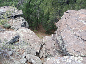
Hike This is a pleasant, shaded trail connecting FR 413 and Trail #110. I hiked it as part of a 7-mile loop beginning with the Coleman Trail #108, 0.4 miles on FR413, 2.3 miles on this trail, 0.7 miles on #110, and road walking 104B, 104, and 104A back to the car. The trail itself is evident on the ground with a couple of cairns where one might become confused. It is mostly dirt and somewhat overgrown in places. Beginning at FR413, the trail is a double track marked by a fiberglass signpost at N34 40.018 W112 06.610. Approaching FR413 from #108, there is a pullout just before reaching the trailhead on the right. The trailhead for Black Canyon Trail #114 is just past this trailhead on the left. On this trail, at about 0.1 miles, there is a flat area used by campers. At about 0.2 miles, the trail crosses the stream bed and becomes a single-track for the balance of its distance. It continues up the canyon, crossing the stream bed several times. The grade is gentle to moderate gaining 920 feet over the 2.3 miles. At about 1.7 miles, you see a cliff on the canyon's left side, which is a viewpoint from the Gaddes Canyon Trail #110. It is also near this point where the old trail must have turned northeast out of the canyon connecting to the 1-mile segment still remaining at the top of the plateau. I could see no evidence where this turn was. The current #9037 continues up the canyon and intersects with trail #110 at N34 41.313 W112 07.958. There is a fiberglass trail sign at this intersection. Turning right on #110 will bring you back to the trailhead for #110 at FR104B. If you parked at Trail #108, continue on FR104B to FR104. Turn right and continue to the "T" intersection and turn right on FR104A toward the camping area. Continue on FR104A back to your car. The short 1-mile segment of Trail #9037 begins about 50 yards north of the #108 trailhead on FR104A on the same side of the road marked by a fiberglass sign at N34 41.314 W112 07.190. This is a rocky section of trail that begins as a wide two-track until you reach Dry Lake Tank on the left at about 0.2 miles. Then it becomes single-track marked by cairns. However, there are frequent cairns, so you should see the next cairn as you pass each one. However, you have to look carefully to spot some cairns as blowdowns and foliage hide them. The trail ends at the edge of Gaddes Canyon with a partially obstructed view. The highpoint for me on this section was that I spotted a small group of 6 - 8 elk near the trail. I did not know elk were in this area. Upon reaching the end of the trail, return the way you came. There is about 300 feet of elevation gain returning to the trailhead. Check out the Official Route and Triplogs. Leave No Trace and +Add a Triplog after your hike to support this local community. One-Way Notice This hike is listed as One-Way. When hiking several trails on a single "hike", log it with a generic name that describes the hike. Then link the trails traveled, check out the example. | ||||||||||||||||||||||||||||||||||||||||||||||||||||||||||||||||||||||||||||||||||||||||||||||||||||||||||||||||||||||||||||||||||||||||||||||||||||||||||||||||||||||||||||||||||||||||||||||||||


