 Route Editor

| Guide | ♦ | 14 Triplogs | 0 Topics |
details | drive | permit | forecast | route |
stats |
photos | triplogs | topics | location |
| 189 | 14 | 0 |
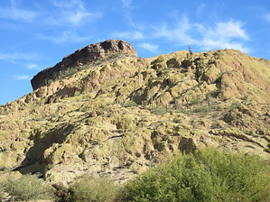
Keep the Faith by DixieFlyer  Overview OverviewThe Hope is Lost Trail is a connector trail that runs through Orohai Wash, just west of Top Hat Hill and Palo Verde Arch. The Hope is Lost Trail runs north-south, and it connects FR 1356 with the Horse with No Name Trail. Hike The starting point of this trail(33.49372, -111.51256) is just SW of Top Hat Hill, at the northernmost point of FR1356.
Along the way to Horse with No Name Trail, there is a good use trail to the east that goes 1/4 mile or so up to Palo Verde Arch, a prominent landmark in the Goldfields. From this use-trail, you could also go off-trail to the summit of Top Hat Hill. The section of Hope is Lost Trail that goes through Orohai Wash is a bit sandy in some places, which will slow you down a bit. However, there is no vegetation to deal with in the wash, so the hiking is relatively easy. Note that the name of the Hope is Lost Trail comes from the mountain biking community, which has come up with several colorful trail names in the Goldfields. Synopsis While this won't be the most memorable trail that you have ever hiked, it provides a good way to get up to either Palo Verde Arch or Top Hat Hill. The trail is also useful to connect to Horse with No Name Trail, which can be used as a springboard to get to arches, peaks, and other landmarks in the central Goldfields. Check out the Official Route and Triplogs. Leave No Trace and +Add a Triplog after your hike to support this local community. One-Way Notice This hike is listed as One-Way. When hiking several trails on a single "hike", log it with a generic name that describes the hike. Then link the trails traveled, check out the example. | ||||||||||||||||||||||||||||||||||||||||||||||||||||||||||||||||||||||||||||||||||||||||||||||||||||||||||||||||||||||||||||||||||||||||||||||||||||||||||||||||||||||||||||||||||


