 Route Editor

| Guide | ♦ | 5 Triplogs | 0 Topics |
details | drive | no permit | forecast | 🔥 route |
stats |
photos | triplogs | topics | location |
| 47 | 5 | 0 |
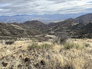
Stumbling Up the Hill by MEWhiteman  Overview OverviewDeer Flat #1009 is a rough TRAL ORV route that takes you to views of the Verde Valley. At the 2-mile mark, it begins to enter the burn area from the Sept/Oct 2020 14,500 Sears fire. It follows a rocky FR1099 from Seven Springs Road to the viewpoints and is easy to follow. Hike From the small parking area, go through the gate. The trail follows FR1099 and is easy to follow. There are a couple of other forest roads crossing your route in the first 1/4 mile, just be sure to stay on 1099. At about 0.5 to 0.75 miles you begin a long, slow climb up the hill. This is very rocky, so watch your footing. To the north, you get a good view of Humboldt Mountain with the big white ball on top. The trail levels out at about 2.2 miles, where you pass a pet cemetery on the left and shortly come to the great view to the east which is the primary objective of the hike. This is a great place for a snack. From here the trail begins to descend as it fishhook back toward the southwest. It continues for about another 3/4 mile where the turnaround point is. Return to your vehicle the way you came.
This route provides relatively easy access to Maverick Butte and Willow Spring Mountain. Views along the route include the New River Mountains, Mazatzal Mountains, Superstitions, and the McDowell Mountains. Gate Policy: If a gate is closed upon arrival, leave it closed after you go through. If it is open, leave it open. Leaving a closed gate open may put cattle in danger. Closing an open gate may cut them off from water. Please be respectful, leave gates as found. The exception is signage on the gate directing you otherwise. Check out the Official Route and Triplogs. Leave No Trace and +Add a Triplog after your hike to support this local community. One-Way Notice This hike is listed as One-Way. When hiking several trails on a single "hike", log it with a generic name that describes the hike. Then link the trails traveled, check out the example. | |||||||||||||||||||||||||||||||||||||||||||||||||||||||||||||||||||||||||||||||||||||||||||||||||||||||


