Route Editor

| Guide | ♦ | 27 Triplogs | 1 Topic |
details | drive | no permit | forecast | 🔥 route |
stats |
photos | triplogs | topic | location |
| 358 | 27 | 1 |
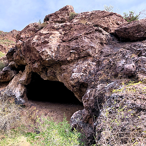
The Big Kahuna’s Lost Cousin by ScottHika  Introduction IntroductionThis is a short under two-mile one-way trip to a once inhabited cave. The hike can be accessed from either Lost Goldmine Trailhead east or take the longer route from LGM Hieroglyphic (west). It is roundtrip under four miles out-and-back with 450 AEG. Overview The Shaka Cave is a primitive natural cave, not a prospect or abandoned mine. It is at least 40 feet wide, 20+ feet deep and 20 feet high in places. It shares proximity to the big Kahuna Wave Cave. You cannot hang-ten off a giant rock wave, but it offers an alternative view of Carney Springs and a few other surprises. This guide overviews a one way trip from LGM east. Use the same route to return to the trailhead where you started. You can add a side trip to the Dacite Cliffs mine, the Wave, Carney Springs/Ridgeline, the Carney Springs Waterfall, or follow Lost Goldmine all the way across to the Hieroglyphics trailhead at Cloudview..
First nation’s people like the Salado and Hohokam lived in the area a thousand years ago, and a cave would be welcomed shelter. The size, the closeness to a natural spring, and food made it inhabitable. There are several Indian grind holes near the entrance as testament. Mortar holes were the product of grinding native plants into a type of meal. The bedrock metates were possibly created while processing Palo Verde and/or Manzanita, which are everywhere and were known to be staples. Please take nothing and leave no trace. Shaka Cave has little known connection to Pete Carney. If this cave was packed with Dutchman’s gold, the Carney miners likely cleaned it out a hundred years ago? Peter Carney mined the area beginning in late 1905. He drilled deep drifts into the Dacite cliffs and deep shafts from the top and mined other nearby areas. He had dreams of striking it rich in the booming copper market. Pete was a tenacious promoter and managed a nearby camp. He capitalized on the available spring water and funds from investors. At one time, Pete had a dozen structures and people working at Carney Camp (Bowers Camp). Newspapers are loaded with clips about Peter G. Carney and his mining exploits. He made due financially but never struck the bonanza. The camp was abandoned following a decade of hard work, high expenses, and little profit. Carney Springs is named after him as his legacy. Over a century later, the area is still littered with remnants like broken concrete, pipes, and castoff metal cans and glass. This cave is not mentioned by Carlson or by Kollenborn. The Lost Goldmine Trail was granted in 1994 and completed in 2002 and runs 11 miles basically east-west. The LGM trail partially connects Peralta with Lost Dutchman State Park across the southern edge of the Superstition Mountains. El Don's base camp was founded 90 years ago and is located just north of the LGM trailhead east lot. It is a gated entrance “permit only” club and organization that preserves legends and AZ lore. They have regular camp activities, including a well-known annual event. Hike Begin at Lost Goldmine Trailhead east. Head west while keeping the fence and looming Dacite Cliffs on your right. The fence is the southern boundary of the Superstition Wilderness area. If you want a side trip, you can visit one of the Dacite Mine shafts. According to Carlson, this shaft is 300 yards long to the very end. It is gated and a haven for bats. You enter the fence opening directly across from the new Wave Cave sign at the 0.8-mile mark. Head toward the cliffs 0.4 miles, turn right, and return the same way. The Dacite mine is not a necessary part of this trip. Continue west on Lost Goldmine until you reach the Carney Springs connector about the 1.2-mile mark. In 2020 someone stole the trail signs, so there is only a standing post (possibly by the same people that spray-painted arrows on rocks along the very obvious trail). Weave through the fence and bear right when you come to another post without a sign about 300 yards up. A right turn (north) takes you up the Ridgeline trail and the Shaka Cave (The left turn takes you up to the Wave Cave). Three Sisters stands prominently to the northwest, so consider a few scenic pictures along the way. The tip of Turks Head pops up further to the west. Up the northern canyon looms West Boulder with its enigmatic hoodoos and a route to summit 5057. You are now at Camp Carney. The original mining camp was at the junction of where the Wave Cave and the Carney Spring trails split. A little farther up, there is an unnamed cross trail about the 1.5-mile mark. To confirm the turnoff location, you can head left (west) 20 yards to find a concrete basin with a pipe sticking out of the top. This was a forest service camp created in the 1950s to accommodate scouts, campers and picnickers. There was a huge patio shaded by Mesquite trees, picnic tables, portable toilet, water tank and fountain. They were removed by the forest service in the early 1970s leaving only the cistern, pipes and broken concrete debris. The hope was to return the area back to wilderness by removing man made improvements. When you are ready, proceed due east from the basin, cross over Carney Springs trail, and you will find yourself on the route to the Shaka Cave. Downloading the Route Scout official route will make the final leg of the journey easier. Pass through the underbrush, mindful not to catch a thorn or two. Carefully navigate the boulders down through the wash at the center of the draw. The trail picks up on the eastern side and bears northeast. It isn’t overly hazardous, but watch your step for loose rocks and scree. There are definite ankle breakers, so be alert. Enjoy the walk while winding northeast through a small Saguaro forest as the elevation increases. The trail proceeds toward a small outcropping of rock that will begin to come into view. There may be game trails, so watch the trail as you scramble up the final section. Hook right and approach the entrance of the cave from the north. It isn’t easy to see until you are practically there. Traverse the bedrock “tongue” and look out for hidden rollers! First impressions - Shaka looks a bit like two lips from the “mouth” of the cave. Look up and go inside. The way back is all downhill. Carefully retrace your steps along the social trail, mindful of loose rocks. Cross the overgrown arroyo, head left on Carney Springs, head left on LGM, and back to the trailhead. Gate Policy: If a gate is closed upon arrival, leave it closed after you go through. If it is open, leave it open. Leaving a closed gate open may put cattle in danger. Closing an open gate may cut them off from water. Please be respectful, leave gates as found. The exception is signage on the gate directing you otherwise. Check out the Official Route and Triplogs. Leave No Trace and +Add a Triplog after your hike to support this local community. | ||||||||||||||||||||||||||||||||||||||||||||||||||||||||||||||||||||||||||||||||||||||||||||||||||||||||||||||||||||||||||||||||||||||||||||||||||||||||||||||||||||||||||||||||||||||||||||||||||||||||||||||