username
X
password
register
for free!
help


Spade Peak 4090 - Harcuvar Mtns, AZ

Guide 1 Triplog  0 Topics
  4 of 5  
Fav
Wish
0
details
drive
no permit
forecast
route  
stats
photos
triplog
topics
location
0 1 0
Statistics
tap row or icons for details
Difficulty 2.5 of 5
Route Finding 2 of 5
Distance Round Trip 1.24 miles
Trailhead Elevation 3,614 feet
Elevation Gain 470 feet
Accumulated Gain 500 feet
Avg Time Round Trip 1 hour
Kokopelli Seeds 3.74
 Interest Off-Trail Hiking, Historic & Peak
 Backpack Possible - Not Popular
feature photo
Photos Viewed All MineFollowing
25  2020-12-13
Harcuvars: Spade - Smith - Bullard
DixieFlyer
Author
author avatar Guides 99
Routes 1,484
Photos 16,072
Trips 1,374 map ( 13,602 miles )
Age Male Gender
Location Fountain Hills, AZ
Associated Areas
list map done
Southwest Region
Historical Weather
Trailhead Forecast
Radar Map
Expand Map
Preferred Feb, Jan, Dec, Mar
Seasons   Autumn to Spring
Sun  6:09am - 6:55pm
Official Route
 
1 Alternative


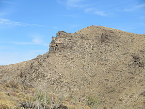
An ace called Spade
by DixieFlyer

  
Overview
Spade Peak 4090 (elevation of 4,090' and prominence of 470') is in the Harcuvar Mountains in west-central Arizona.


Hike
This hike is entirely off-trail, although it is not too difficult as far as off-trail hiking goes.
remove free decal offer
From the parking area, you'll see a rock outcropping on a sub-peak to the north. It is best to go to your right and go around the east side of this rock outcropping. You'll want to get on a ridgeline on the north side of the rock outcropping. The going is a bit steep getting to the ridgeline, but things get much easier once on the ridgeline. Once on the ridgeline, stay on the left side of a fence on the ridgeline. As you get close to the peak, the fence goes off to your right; at this point, you are not far from the summit, so make the reasonably easy walk to get to the summit.

After enjoying the 360-degree views, return the way that you came to get back to your car.

Synopsis
This is a nice peak to summit, but given the area's remoteness, you probably don't want to go all the way out there just to do this short hike. Thus, most hikers will do some other hiking in the area. Good choices include Smith Peak, the Bullard Benchmark, Bullard Peak, and the Bullard Mine complex.

2020-12-13 DixieFlyer


    Check out the Official Route and Triplog.
    Leave No Trace and +Add a Triplog after your hike to support this local community.
    WARNING! Hiking and outdoor related sports can be dangerous. Be responsible and prepare for the trip. Study the area you are entering and plan accordingly. Dress for the current and unexpected weather changes. Take plenty of water. Never go alone. Make an itinerary with your plan(s), route(s), destination(s) and expected return time. Give your itinerary to trusted family and/or friends.

     Permit $$
    None


     Directions
    or
     Road
    Strictly 4x4

    To hike
    From the town of Aguila, take Eagle Eye Road north of off Highway 60. You'll want to take the road that goes up to the towers on Smith Peak. After about 14 miles you'll park at a small pullout just after you go through some switchbacks.

    Note that the unpaved road is generally well maintained, and an AWD vehicle with decent clearance should be able to get to the parking area if the road is dry. However, about a mile or so before getting to the parking area there is a sign on the road asking drivers to use 4WD in order to save wear on the road; hence, the road is listed as 4WD only in this guide.

    GPS track for the drive.
    page created by DixieFlyer on Dec 13 2020 7:49 pm
     90+° 8am - 6pm kills
    helpcorrectionissue

    end of page marker