username
X
password
register
for free!
help
  🔥

Black Mesa - Superstition Mountains, AZ

Guide 11 Triplogs  0 Topics
  2.9 of 5  
Fav
Wish
0
details
drive
no permit
forecast
🔥
route  
stats
photos
triplogs
topics
location
69 11 0
Statistics
tap row or icons for details
Route Finding 2 of 5
Distance One Way 3.3 miles
Trailhead Elevation 2,289 feet
Elevation Gain 561 feet
Accumulated Gain 700 feet
Avg Time One Way 4 hours
Kokopelli Seeds 5.63
 Interest Off-Trail Hiking
feature photo
Photos Viewed All MineFollowing
Inaugural Calculation on Button Tap!
14  2025-03-18
Black Mesa Loop - Superstition Mtns
Tortoise_Hiker
8  2025-03-18
Black Mesa Loop - Superstition Mtns
wallyfrack
28  2024-05-25
Black Mesa Loop - Superstition Mtns
adilling
8  2024-01-12
Garden Valley - Hackberry Loop
rayhuston
10  2024-01-06
Black Top Mesa Loop
rayhuston
5  2023-06-24
Black Mesa Loop - Superstition Mtns
rayhuston
8  2022-10-30 wallyfrack
29  2022-02-17
Superstitions Superfecta
DixieFlyer
Page 1,  2
Author
author avatar Guides 116
Routes 337
Photos 11,399
Trips 894 map ( 8,139 miles )
Age 63 Male Gender
Location Sunnyslope, PHX
Associated Areas
list map done
Phoenix Region
Historical Weather
Trailhead Forecast
Radar Map
Expand Map
Preferred Jan, Dec, Feb, Nov
Sun  6:02am - 6:47pm
Official Route & 3 Rts
 
4 Alternative
 
Historic Fire Perimetersacres
🔥 2024 Siphon Fire35.9 mi*
🔥 2020 Superstition Fire9.6k
🔥 View (All) - over Official Route 🔥
*perimeter length in miles


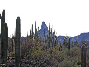
It was green: Now it's black.
by kingsnake

Overview
Black Mesa borders the southeast edge of Garden Valley in the Superstition Mountains. You can most easily access it from the south via Black Mesa Trail #241, or from the north via Second Water Trail #236. First Water is the nearest trailhead.


Black Mesa has a prominence of ~300 ft. above Garden Valley and the south end of Second Water Creek, ~800 ft. above the north end of Second Water Creek. It is much steeper on the west side (Garden Valley), gradually sloping away to the east. It is ~2.0 miles long, with a maximum altitude of 2850 ft., at its south end, opposite Yellow Peak.
remove free decal offer
Prologue
Several unofficial routes on HAZ cross Black Mesa, but none traverse its length, nor a description. I just want an essential guide for the mesa to attach my triplog to, rather than some random trails. :-)

Hike
Getting to the "summit" from First Water TH, via Second Water Trail #236 and Black Mesa Trail #241, is 3.3 mi., 700 AEG. It's an easy 100 ft. off-trail climb from the open area on the saddle at the top of Trail #241. Meh.

I made a loop of it by traversing the highline (as it descended) back to Trail #236, across the north edge of Garden Valley, down to the Hackberry Springs signs, before instead turning south down the valley towards the First Water Ranch, then back to the trailhead. That's 7.45 mi., 980 AEG.

2020-12-20 kingsnake


    Check out the Official Route and Triplogs.
    Leave No Trace and +Add a Triplog after your hike to support this local community.

    One-Way Notice
    This hike is listed as One-Way.

    When hiking several trails on a single "hike", log it with a generic name that describes the hike. Then link the trails traveled, check out the example.
    WARNING! Hiking and outdoor related sports can be dangerous. Be responsible and prepare for the trip. Study the area you are entering and plan accordingly. Dress for the current and unexpected weather changes. Take plenty of water. Never go alone. Make an itinerary with your plan(s), route(s), destination(s) and expected return time. Give your itinerary to trusted family and/or friends.

     Permit $$
    None


     Directions
    or
     Road
    FR / Dirt Road / Gravel - Car Okay

    To First Water Trailhead
    From Mesa follow Highway 60 East to Idaho Road. Turn North onto Idaho Road which is SR88 and follow North 2.2 miles. SR88 bends right just past Scenic St. and Idaho continues North. Be sure to go right and stay on SR88. Follow SR88 5.2 miles to the signed turnoff for First Water Trailhead, this is FR-78. Turn right on to FR-78 and follow 2.6 miles to the end.

    This trailhead feature restrooms without running water. The large parking area fills up in season. When full utilize the Horse Lot 0.5 miles back.

    From PHX (I-10 & AZ-51) 43.1 mi - about 59 mins
    From TUC (Jct 1-10 & Grant) 136 mi - about 2 hours 16 mins
    From FLG (Jct I-17 & I-40) 187 mi - about 3 hours 3 mins
    page created by kingsnake on Dec 20 2020 3:10 pm
     90+° 8am - 6pm kills
    helpcorrectionissue

    end of page marker