Overview
Access to the Black Mesa Trail from the north is usually from the First Water Trail Head via the Second Water Trail. The Black Mesa Trail from North to South starts along the Second Water Trail at a signed intersection on the south side of Garden Valley. From this intersection looking north are Hackberry Mesa on the far side of Garden Valley and Black Mesa to the south (Actually is southeast but I will be referring to this trail as a north-south trail). The Black Mesa Trail crosses Black Mesa diagonally along the southern portion of the mesa and ends after dropping into Boulder Canyon for a total of 3 miles.
Geology Black Mesa stands out from other areas in the Superstitions in that it has a layer of black basaltic rock capping it, like chocolate frosting on a light colored cake. This 3 million year old basalt flow is fairly recent compared to the rest of the Superstition caldera complex which dates from 15 to 30 million years (They believe there were at least 3 separate calderas in this area between 15 and 30 million years ago). The darker more recent basalt is in contrast to the older, lighter colored dacites and volcanic tuffs.
Hike
The Black Mesa Trail from the Second Water Trail heads up an unnamed canyon with a gradual climb to a saddle which is the high point of this trail. On the first part of this trail are good views to the west of the Superstition Mountains and The cliffs near the Massacre Grounds. Once further up the trail views are limited because Black Top Mesa rises on either side. The saddle at the high point is not very noticeable but the trail levels out for a short distance. The most prominent feature is a very small hill on the west side of the trail with a nice stand of saguaros. Weavers Needle makes its appearance when you approach the saddle.
Once at the high point, the trail immediately starts to head down another unnamed canyon to Boulder canyon. The next 1.7 miles drop 540 feet to Boulder Canyon, this section is steep and rocky but easy to follow. To the east, Yellow Peak is in view most of the way down. A short distance after crossing Boulder Canyon is the intersection with the Dutchman Trail. This large flat open area along Boulder Creek is Boulder Basin and the site of what once was the old Brush Corral.
When doing the Black Mesa – Dutchman Loop from the First Water Trailhead, it is recommended that you do this in a Clockwise direction (Second Water to Black Mesa then Dutchman), this direction avoids the steep rocky climb up to Black Mesa from the south. This loop hike can be combined with treks up to Black Top Mesa or Aylor’s Arch making for a nice 13 mile hike.
When hiking several trails on a single "hike", log it with a generic name that describes the hike. Then link the trails traveled, check out the example.
WARNING! Hiking and outdoor related sports can be dangerous. Be responsible and prepare for the trip. Study the area you are entering and plan accordingly. Dress for the current and unexpected weather changes. Take plenty of water. Never go alone. Make an itinerary with your plan(s), route(s), destination(s) and expected return time. Give your itinerary to trusted family and/or friends.
Permit $$
None
Directions
Road
FR / Dirt Road / Gravel - Car Okay
To First Water Trailhead From Mesa follow Highway 60 East to Idaho Road. Turn North onto Idaho Road which is SR88 and follow North 2.2 miles. SR88 bends right just past Scenic St. and Idaho continues North. Be sure to go right and stay on SR88. Follow SR88 5.2 miles to the signed turnoff for First Water Trailhead, this is FR-78. Turn right on to FR-78 and follow 2.6 miles to the end.
This trailhead feature restrooms without running water. The large parking area fills up in season. When full utilize the Horse Lot 0.5 miles back.
From PHX (I-10 & AZ-51) 43.1 mi - about 59 mins From TUC (Jct 1-10 & Grant) 136 mi - about 2 hours 16 mins From FLG (Jct I-17 & I-40) 187 mi - about 3 hours 3 mins
 Route Editor

 Overview
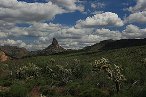


