Route Editor

| Guide | ♦ | 1 Triplog | 0 Topics |
details | drive | permit | forecast | map |
stats |
photos | triplog | topics | location |
| 8 | 1 | 0 |
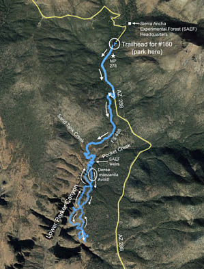
Ornery Manzanita - Rewarding Experience by JoeSchallan  Warning WarningHealth hazard: Short-fiber asbestos in mats in bed of Pocket Creek, washed down from the old American Ores Mine between Asbestos Point and Zimmerman Point. Overview Explore structures built for the watershed research conducted in the Sierra Ancha Experimental Forest; enjoy spectacular views from the top of the high eastern cliffs of lower Parker Canyon.
Beginning in 1932, researchers stationed at Parker Creek studied rainfall, water absorption and run-off, and erosion and siltation, and the effects of cattle grazing. (This was pioneering work in arid lands hydrology generally and insight into the nature of Phoenix's water supply specifically.) Two weirs remain in Parker Canyon below State Route 288 and a cattle exclusion plot atop the east side of the canyon. Forest Service telephone line remnants through the area are also extant. Hike From Parker Creek Trailhead, walk 2/3 of a mile south along paved 288 to its junction with unpaved Forest Route 488, on your right. Walk on 488 for approximately one mile to the point at which it crosses Sand Tank Creek and turn left into the creek bed. Follow it down to a point near an intermittent waterfall (vertical drop) and find a social trail on your left, which will take you to a crossing of Parker Creek just upstream from where the canyon cliffs begin. At this point, most evidence of a trail disappears, though apparently in the 1930s, a trail existed to provide access to the stream-gauge weirs and experimental plots. As you go onward, you will find faint traces of social trails, but to all intents, you will be off-trail after the Parker Creek crossing. The Forest Service weirs and gauges were near the point where Sand Tank Creek and Pocket Creek flow into Parker Creek -- one on each of the three streams. The Sand Tank and Pocket Creek weirs are still in place. You can follow Pocket Creek down to its weir right above the creek's confluence with Parker Creek (being careful not to disturb the matted asbestos in the creek bed). After investigating the weirs, and as you proceed south, try to keep as close to the canyon rim as you can: You will avoid dense thickets of manzanita, and you will have access to spectacular views from the canyon rim as the canyon widens and deepens. Along the way, you may encounter one of the cattle exclusion plots, mostly intact with steel fenceposts and steel-wire fencing. You will also encounter rusty steel poles that once supported the Forest Service's telephone line. Your turnaround will be the high ground, between two side canyons, at 33˚46'07" / -110˚58'37" (33.768611 / -110.976944). Water Sources Sand Tank, Pocket, and Parker Creek when running. Water below the point at which Pocket Creek enters Parker Creek may be contaminated with asbestos. Camping The fully-featured Forest Service / Bureau of Reclamation campgrounds on the south shore of the eastern arm of Roosevelt Lake (Schoolhouse Point, Windy Hill) are about 30 miles away. Dispersed (undeveloped) camping, under large sycamore trees, has been done along Forest Route 488, just across a small concrete bridge over Parker Creek. (Parking or camping here will shorten your hike -- no need to walk 288 from the #160 Trailhead to the State 288 / Forest 488 junction.) Note After crossing Parker Creek on the small concrete bridge, Forest Route 488 becomes high clearance / 4x4 due to erosion and deep rutting. The hike from the #160 Trailhead to the turnaround point and back can be done in under four hours, but exploring the remnants of the watershed-research sites and pausing to enjoy canyon views will extend your time. Inadvertently wandering into the dense manzanita east of the canyon rim will definitely extend your time! Hazards include asbestos, heat from April to October, scrambles and tripping hazards, and the potential of taking a Wile E. Coyote dive off the rim of the main or side canyons. Mind the edge!
Check out the Triplog. Leave No Trace and +Add a Triplog after your hike to support this local community. | ||||||||||||||||||||||||||||||||||||||||||||||||||||||||||||||||||||||||||||||||||||||||||