 Route Editor

| Guide | ♦ | 1 Triplog | 0 Topics |
details | drive | permit | forecast | route |
stats |
photos | triplog | topics | location |
| 0 | 1 | 0 |
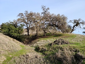
ranch style cardio by PaleoRob  Overview The trail starts at the base of the southern end of the San Felipe Hills just east of San Martin and climbs through rolling hills and past massive live oaks. This description ends at the Town Springs Trail's junction, but the Willow Springs Trail continues up into pines and eventually crosses a ridge overlooking both San Martin and Coyote Lake.
Hike The hike is straight forward. From the parking lot, there are only two major trail options. One loops around a flat pasture and is paved. The other heads for the hills. Take this branch and head towards the hills yourself. The path is obvious, and after about 1/10th of a mile, you'll reach a gate. Cross through this, and the trail begins to rise following a drainage. Another 0.1 miles past the gate is a trail junction with the Harvey Bear Trail on the left (north). This can be used to make a 4+ mile loop, but the Willow Springs Trail continues following the drainage uphill. About 0.1 miles past the Harvey Bear Trail, there is another trail junction on the left, this one unmarked. This is not an official trail, though it is often used by members of the public. Instead, keep to the right and climb the hill's west side as the trail leaves the drainage. Climbing out of the drainage begins to offer a view to the south of Gilroy and Hollister, while Coyote Ridge and the pines become visible to the east/southeast. The trail wraps around towards the east and continues to climb, allowing a better view of the rest of Willow Creek Trail and the end of this segment at a prominent post on the left (north) side of the trail. Just before reaching the junction with the Town Springs Trail, the social trail that you bypassed at the base of the climb comes in on the left. From the signed junction, you can continue uphill to Coyote Ridge Trail or take Town Springs Trail. Both intersect the Harvey Bear Trail and loop back to the Willow Creek Trail. Alternately, you can turn around and proceed back down the trail the way you came. There are plenty of choices! Water Sources None, bring your own. Camping Allowed at the Lakeview Campground, but not on this trail. Gate Policy: If a gate is closed upon arrival, leave it closed after you go through. If it is open, leave it open. Leaving a closed gate open may put cattle in danger. Closing an open gate may cut them off from water. Please be respectful, leave gates as found. The exception is signage on the gate directing you otherwise.
Check out the Official Route and Triplog. Leave No Trace and +Add a Triplog after your hike to support this local community. One-Way Notice This hike is listed as One-Way. When hiking several trails on a single "hike", log it with a generic name that describes the hike. Then link the trails traveled, check out the example. | |||||||||||||||||||||||||||||||||||||||||||||||||||||||||||||||||||||||||||||||||||||


