 Route Editor

| Guide | ♦ | 3 Triplogs | 0 Topics |
details | drive | no permit | forecast | route |
stats |
photos | triplogs | topics | location |
| 0 | 3 | 0 |
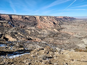
Nibble on the Raptor by PaleoRob  Mountain biking can be dangerous - please know your skill level and be appropriately prepared with PPE before starting any trail. Overview This section of the Eagle Wing Trail offers excellent views of the Little Park area and the eastern section of the Colorado National Monument. It also provides great connection opportunities to other trails to make loops or longer shuttle trips.
Starting at the Lunch Line Trail intersection, the first quarter-mile of the trail climbs towards a prominent series of rim boulders. Gaining approximately 100 feet in this first stretch, this is the only serious uphill of the hike. A little past the quarter-mile point, the trail splits. The Free Lunch Trail breaks off to the right; this trail is for mountain bikes only and is exceptionally challenging. The Eagle Wing Trail stays to the left and follows the canyon's rim, contouring just below the caprock in places. Not quite a quarter mile past the Free Lunch junction, the trail reaches its high point on a ridge with good views to the south and west. It bends sharply north at this point, which may not be obvious depending on trail conditions. From here, it is all downhill, first crossing through some pinon-juniper woodlands before starting to parallel a cliff edge to the west. The trail here is easy to follow, and the incredible views of the Colorado National Monument are always changing as the trail winds its way across the flats above the rim, slowly descending. The last tenth of a mile is the most challenging section of trail, as the trail drops down into a draw by a series of narrow, tight switchbacks among fallen sandstone ledges. This portion requires careful foot placement and extreme caution if biking. Once through the switchbacks, though, the trail regains its mellow character as it heads into the draw. Not long after leveling out, there is a junction. The junction on the east is the Eagle Connector and will connect into the Tabaguache Trail for possible loops back to the trailhead or down into the Lower Morrison Basin. Heading straight will take you along the next segment of the Eagle Wing Trail down towards the popular Lunch Loops area off of Monument Road. Water Sources None, bring all you need. Camping No. Note This trail is rated Black (Advanced) for mountain bikers. Check out the Official Route and Triplogs. Leave No Trace and +Add a Triplog after your hike to support this local community. One-Way Notice This hike is listed as One-Way. When hiking several trails on a single "hike", log it with a generic name that describes the hike. Then link the trails traveled, check out the example. | ||||||||||||||||||||||||||||||||||||||||||||||||||||||||||||||||||||||||||||||||||


