 Route Editor

| Guide | ♦ | 1 Triplog | 0 Topics |
details | drive | no permit | forecast | route |
stats |
photos | triplog | topics | location |
| 0 | 1 | 0 |
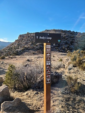
Now Kaufman, did you hear about this one? by PaleoRob  This trail is steep with several exposed sections. It is built on Morrison clay, which makes it a nightmare when it is wet. It is also south-facing, which means it can get very hot, especially on a summer afternoon. Mountain biking can be dangerous - please know your skill level and be appropriately prepared with PPE before starting any trail. Take these factors into account when planning your trip. Overview This segment of Andy's Loop descends from the Little Park Road and offers access to the Echo Canyon/Lunch Loops segment of Andy's Loop or the challenging Ribbon Trail. The trail follows a historic road for the first 1/3 and then winds among badlands from the Jurassic Period on its way to the canyon bottom.
The hike is straightforward. From the trailhead/parking area, a well-marked and defined trail crosses some pinon-juniper scrub before reaching a small draw. The old road is visible on the south side, but the trail follows the north bank. It quickly drops down the draw as it becomes steeper and winds around boulders and slopes. There are a couple of switchbacks where the trail traverses resistant sandstone ledges. Eventually, after a rugged downhill, the trail reaches the bottom of Echo Canyon. You may encounter dry sand, isolated pools, or running water depending on the time of day and year. Once at the bottom of the trail, you can either turn left and head up the Ribbon Trail, turn right and head downcanyon on the next segment of Andy's Loop, or turn around and head back up the trail to the parking area. Water Sources Echo Canyon flows after a heavy runoff, but plan on bringing your own. Camping Day use area only. Note This trail is rated Black Diamond (Advanced) for mountain bikers. Check out the Official Route and Triplog. Leave No Trace and +Add a Triplog after your hike to support this local community. One-Way Notice This hike is listed as One-Way. When hiking several trails on a single "hike", log it with a generic name that describes the hike. Then link the trails traveled, check out the example. | |||||||||||||||||||||||||||||||||||||||||||||||||||||||||||||||||||||||||||||||||||||


