Route Editor

| Guide | ♦ | 1 Triplog | 0 Topics |
details | drive | no permit | forecast | map |
stats |
photos | triplog | topics | location |
| 22 | 1 | 0 |
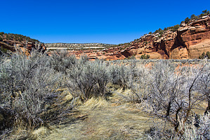
explore the tale of two routes by PaleoRob  Seiber Canyon is very remote with no cell service, no formal trail, and is seldom visited. The descent into the canyon is decently exposed. Remember to leave an itinerary with others before your trip. Overview Seiber Canyon cuts through the slickrock Entrada and Wingate sandstones exposed in McInnis Canyons National Conservation Area to the west of Glade Park. The trail allows access to the upper portion of Lower Seiber Canyon below a major pourover.
The Ute people have inhabited this area for literally thousands of years, and traces of their occupation and their ancestors can be seen across the region, including in Seiber Canyon. In the 1880s, the Utes were forcibly removed by the governor of Colorado and the US Military. Following this, settlers began claiming land in the region. This included Basque sheepherders who settled in the Glade Park area. Some of these new Euro-American settlers visited Seiber Canyon and left their marks on the canyon. Today the canyon is still a range for cattle as part of McInnis Canyons National Conservation Area. Hike The hike starts just past the Knowles Canyon trail, on the west side of Seiber Canyon. A quick spur leads to an overlook of Seiber Canyon, but the trail itself heads northeast down to the canyon bottom at a junction with a side canyon coming in from the east-southeast. There are multiple cattle trails down, so finding a correct route isn't essential. Once on the canyon bottom, though, you'll want to ascend the slickrock that forms the point between Seiber and the side canyon. Once on the slickrock, occasional cairns mark the route up into the pinyon-juniper forest. Here several trails branch off, and while cairns may mark them, some of them end up petering out into nothing. The best bet is to follow close to the rim. There are two routes down into the canyon - a harder-to-find route that is less exposed and more gentle, and a steep, north-facing route that is easier to find. Neither is cairned, so sharp eyes and perhaps a review of previous GPS routes and GoogleEarth will help folks find the best way down for the conditions. The north-facing route is especially hazardous during the winter and early spring owing to snow, and crampons may be required. The canyon bottom is cut by a deep arroyo, and you will need to descend into the arroyo bottom to continue downstream. The easiest way to do this is to hug the canyon's south wall, navigating the sage jungle until passing a point of rock defining a side canyon. At this point, find a cattle track heading towards the northwest - this is a point of canyon bottom extending into the arroyo. There is a trail heading down the east side of the point into the arroyo. Once on the arroyo bottom, you've covered about a mile, and from there, it is smooth sailing. Most folks venture downcanyon for a mile or so before turning around, but further exploration is possible. Water Sources None that are reliable. Bring all you need. Camping People do camp at times at the trailhead, and backpacking is possible in the canyon but not terribly popular. Check out the Triplog. Leave No Trace and +Add a Triplog after your hike to support this local community. | ||||||||||||||||||||||||||||||||||||||||||||||||||||||||||||||||||||||||||||||||||||||