Route Editor

| Guide | ♦ | 2 Triplogs | 0 Topics |
details | drive | permit | forecast | route |
stats |
photos | triplogs | topics | location |
| 11 | 2 | 0 |
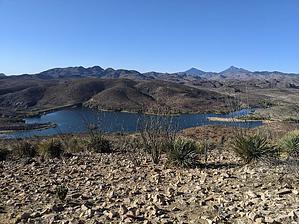
Great View of the Lake by KingLeonidas   2024 2024Due to vandalism, a free day use permit is required and the area closes at 4 PM Intro Overlook Trail is one of several hiking trails [ map ] located in Patagonia Lake State Park's vicinity. It is a short trail that gives a superb view of the Lake from the top.
The trailhead can be accessed by car by turning left immediately before the Lake Patagonia entrance and Ranger station. There is a parking lot down a short dirt road for accessing several nearby trails. The trailhead is also accessible to boaters/paddlers (which is how we got there) by going ashore on the spillway's left-hand side (boat up campsite 118 is also in the vicinity). Permit No permit is needed to park in the parking lot. If you are accessing by water, Lake Patagonia day-use permits or camping reservations are required to access the park. Navigation The trail is somewhat faint, and it doesn't look like it gets much traffic. However, each trail intersection was marked with signs, so navigation is not difficult. Trail Conditions The surface was mostly packed dirt and larger rocks, nothing very technically challenging. Weather We did this hike in early April in the afternoon. It was warm but not uncomfortable. General Comments and Musings The landscape on this trail was interesting. The earth and rocks were an orange/clay type color. Not quite the red you see up in Sedona but not the usual desert tan either. The vegetation was almost exclusively ocotillo; I don't think I have seen another place with quite this high concentration. While we were there, they were starting to flower in some cases but were not green yet. This was unfortunate as I imagine that the green leaves would contrast the orange earth quite nicely. The views of the lake from the top were spectacular. You can see the entirety of it from the top, and there is a bench up there to relax and take it in. A plaque is also on the summit. If you are camping at the lake, this is a good spot to stretch your legs.
Check out the Official Route and Triplogs. Leave No Trace and +Add a Triplog after your hike to support this local community. | |||||||||||||||||||||||||||||||||||||||||||||||||||||||||||||||||||||||||||||||||||||