 Route Editor

| Guide | ♦ | 2 Triplogs | 0 Topics |
details | drive | permit | forecast | 🔥 route |
stats |
photo | triplogs | topics | location |
| 1 | 2 | 0 |
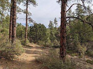
  Spence Creek Trail is one of the trails in the Spence Springs Basin just west of Prescott, Arizona. For a full description of the trails in the Spence Springs Basin, see the description of Noodle Loop Trail #760, which is the only trail from the Spence Springs Trailhead. Spence Creek Trail is one of the trails in the Spence Springs Basin just west of Prescott, Arizona. For a full description of the trails in the Spence Springs Basin, see the description of Noodle Loop Trail #760, which is the only trail from the Spence Springs Trailhead.Unlike most of the trails in the Spence Springs Basin, Spence Creek Trail is most easily accessed from the Iron Springs Trailhead via West Side Story Trail #725. Spence Creek Trail is a 1/3 mile scenic trail that runs northwest to southeast from West Side Story Trail #725 to Javelina Trail #332 along Spence Creek between hills Check out the Official Route and Triplogs. Leave No Trace and +Add a Triplog after your hike to support this local community. One-Way Notice This hike is listed as One-Way. When hiking several trails on a single "hike", log it with a generic name that describes the hike. Then link the trails traveled, check out the example. | ||||||||||||||||||||||||||||||||||||||||||||||||||||||||||||||||||||||||||||||||||||


