Route Editor

| Guide | ♦ | 12 Triplogs | 0 Topics |
details | drive | no permit | forecast | 🔥 route |
stats |
photos | triplogs | topics | location |
| 59 | 12 | 0 |
Canyons are inherently risky. Flash floods occur without notice on sunny days. Technical skills & surrounding topography knowledge required yet does not eliminate risk.
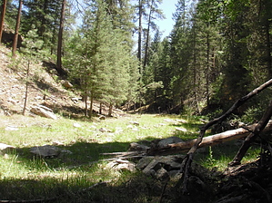
West Clear Creek the hard way. by nonot   Overview OverviewA trip down Toms Creek to Clover Creek and down Clover until you reach the confluence with Willow Valley and arrive in West Clear Creek. Warning This is a slightly challenging route and is entirely off-trail. You don't want to be in this canyon in a flash flood; check the weather report carefully for any signs of rain before you go. It will be easier going downstream than going upstream. There were no particularly difficult obstacles when the canyon was ascended mostly dry in early August 2009.
From FR142, walk the rancher's road to your north. You may see cows in the area (cows are not exceptionally bright animals, so don't spook them). The dirt road lasts about 3/4 of a mile and is easy to follow. Eventually, the road ends, and the canyon begins. It is relatively pleasant at first. The water is shallow and cool, and the trail is easy and obvious. You walk in grassy little pockets for a while. Then, it gets harder. A few logs are strewn about, and some boulders block the canyon from time to time. You will have to scramble around them. After a short bit of this, the easy canyoneering resumes, and you are strolling along in the grass. A large open area is found to your right looking down the canyon, where there is a wide expanse of flat ground and one or two campfire rings. Continue going down the canyon. Unfortunately, it gets tougher, much tougher. The rocks and logs get more numerous. The canyon gets a bit steeper. Bypass trails will help amongst the most difficult obstacles. Water appears infrequently. First, you generally see scuzzy pools, and then further downstream, it will be clear and flowing, and then it will disappear underground. The canyon begins to twist and turn, the walls become higher, and eventually, you realize you cannot escape the canyon after you have gone two miles. The canyon bottom gets rocky, and you are scrambling along boulders and ledges. Finally, the last 0.5 miles before you reach Clover Canyon, decent game trails appear, along with an old cow skeleton. Use these trails and enjoy finally getting out of the rock-hopping creekbed. It is about 3.5 miles to Clover Canyon. At Clover Canyon, the trail continues going upstream but doesn't follow it per this hike description. As soon as you reach the Clover Creek creekbed, turn left and rock-hop/bushwhack another 3 miles downstream until you reach WCC. Water sources Good water was found throughout the first 3 miles of this canyon. Near Clover and in Clover was dry until you got very close to West Clear Creek. Camping The wide-open field found about 1-1.5 miles in (you will know it when you get there, it's impossible to miss) and just upstream in Clover Creek where Toms and Clover meet are your only two real camping options until you reach WCC itself. Note: It would be highly advisable to set out a shuttle and go out Maxwell trail. Doing this canyon in both directions is a bit masochistic. Check out the Official Route and Triplogs. Leave No Trace and +Add a Triplog after your canyon trip to support this local community. | ||||||||||||||||||||||||||||||||||||||||||||||||||||||||||||||||||||||||||||||||||||||||||||||||||||||||||||||||||||||||||||||||||||||||||||||||||||||||||||||||||||||||||||||||||||||||||||||||||||||