Route Editor

| Guide | ♦ | 2 Triplogs | 0 Topics |
details | drive | no permit | forecast | route |
stats |
photos | triplogs | topics | location |
| 83 | 2 | 0 |
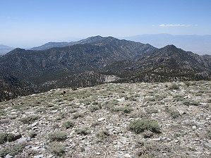
Make Hayford while the sun shines by DixieFlyer Hayford Peak (elevation of 9,912 feet and prominence of 5,392 feet) is the highpoint of the Sheep Range mountains in southern Nevada. Hayford Peak is about one hour north of Las Vegas, and it is within the Desert National Wildlife Refuge, which is the largest wildlife refuge in the continental U.S. It is the 7th most prominent peak in Nevada and the 42nd most prominent peak in the continental U.S. Hike You'll take the unmarked Hidden Forest Trail for 5.3 miles from the trailhead until you get to Hidden Forest Cabin. From the cabin, it is another 2.5 miles on a use-trail to the summit.
Vegetation at the trailhead is typical of a dry desert; Joshua trees, creosote bush, bursage, among others, dominate. This area is in the rain shadow of the Spring Mountains, which results in it getting even less rain than other parts of southern Nevada. As you get into the wash, underground water from the mountains results in comparatively lush vegetation -- desert almond, Apache plume, saltbush, among others, are seen. After about a mile, the Joshua trees are gone, and you get into a forest of pinyon pine and juniper. After three miles or so, Ponderosa pines appear, and before long, you are in a forest of ponderosa pine and some white fir. Continue on the wash and old roadbed until you get to Hidden Forest Cabin. In front of the cabin is a pipe with water from Wiregrass Spring that seems to run most of the time. There are some picnic tables, so this is a good place to take a break. The Hayford Peak summit is 2.5 miles from the cabin. To get there, follow a use trail through a side canyon going north until you get to a ridgeline. When facing the cabin, the use trail is off to your right. The last part of the climb to the ridgeline is a bit steep, and you may be stopping a time or two to catch your breath. One at the ridgeline, the use trail goes in a northeast direction to the summit. From the ridgeline, you'll see a false summit that looks a bit intimidating to climb, but have no fear; you'll sidestep the false summit on the way to the true summit. The true summit does not come into view until you are below it. The ascent from the ridgeline is a bit steep and slippery and would be considered a class 2 climb. However, there is no exposure and nothing that would be concerning to a seasoned hiker. The grade for the first mile or so past the Cabin continues to be relatively modest; thereafter, it steepens quite a bit up to the summit -- you'll be ascending about 1,700 feet in the last 1.5 miles to the summit. There are nice views at the summit, and there are several bristlecone pines at the summit, particularly on the north side of the summit. There are great views of Charleston Peak to the southwest, and on a clear day, you can see Lake Mead off to the southeast. After spending some time at the summit enjoying the scenery, turn around and go back to the trailhead the way that you came. History The Hidden Forest Cabin was originally constructed sometime around 1900, although it is not known who built it. It was used by prospectors, hunters, bootleggers, and even outlaws. It became a game warden cabin in the 1930s when the Desert National Wildlife Refuge acquired the property. At one time, automobiles could drive to the cabin, and there are a few parts from a 1928 Chevrolet near the cabin. Water Sources There is a spring in front of the Hidden Forest Cabin that generally has water, but it might be dry during extremely dry periods. Camping Camping is available along the trail, particularly near the Hidden Forest Cabin, where water is often available. Sleeping inside of Hidden Forest Cabin is also permitted. Note that campfires are not allowed. Synopsis Due to distance and elevation gain, this is not an easy day hike. However, it is doable for an experienced and reasonably fit hiker. Going uphill in the wash for the first 4 miles can be a bit tedious and tiring, but the diversity of vegetation along the way is interesting, and views at the summit are stellar. Check out the Official Route and Triplogs. Note This is a moderately difficult hike. Leave No Trace and +Add a Triplog after your hike to support this local community. | |||||||||||||||||||||||||||||||||||||||||||||||||||||||||||||||||||||||||||||||||||||