Route Editor

| Guide | ♦ | 3 Triplogs | 0 Topics |
details | drive | no permit | forecast | route |
stats |
photos | triplogs | topics | location |
| 77 | 3 | 0 |
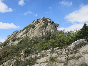
A lot of Bangs for the buck by DixieFlyer  Warning WarningAscending and traversing the summit block of Mount Bangs involves some mildly exposed class 3 rock and boulder scrambling. Those with a fear of heights might have some issues making it all the way to the summit. Overview Mount Bangs (elevation of 8,012 feet and prominence of 2,893 feet) is in the Arizona Strip BLM area in extreme northwestern Arizona. Mount Bangs is in the Virgin Mountain range and the Paiute Wilderness. It is the highpoint of the Wilderness and is the second-highest peak in the Virgin Mountains. For those interested in prominence, Mount Bangs is the 28th most prominent peak in Arizona.
Mount Bangs was named for James E. Bangs, a clerk for geologist and mountaineer Clarence King, who was the first director of the U.S. Geological Survey from 1879-1881. Kings Peak, the highpoint of Utah, is named in honor of Clarence King. In a historical oddity, Mount Bangs was once an Arizona County highpoint: from 1867-1871, it was the highpoint of Pah-Ute County, Arizona's "lost county". Hike This is an out-and-back hike on the Mount Bangs Summit Trail from the Cougar Spring Trailhead. The best time to do this hike is spring through fall. The trail is usually covered in snow by early December and will be snow-covered until sometime in March. Additionally, the BLM1004 road may be closed in winter due to snow, ice, and mud. There are 3 distinct segments of the trail, with the first two following an old roadbed: 1) The first segment goes about 1.5 miles to a saddle near a historic cattle pond. This segment gains about 650 feet in elevation. The trail is partly on dirt and partly on some colorful stream-rounded rocks. Make a left turn at the saddle to go to the west on the easy-to-follow trail. 2) Segment two is a steeper ascent on switchbacks; over about one mile, there is another 650 feet or so of elevation gain. 3) Segment three begins at a viewpoint and continues for about 0.25 miles with about 400 feet of elevation gain. There is some steep class 2 climbing up to the summit block. Once at the summit block, you'll be doing some class 3 rock and boulder scrambling to the summit. Any exposure is mild, and the climbing isn't too difficult, but you'll need to focus on what you are doing. There are cairns guiding the way that will provide a decent route to follow; however, you might find a route better to your liking. The rock at the summit is 1.7 billion-year-old Precambrian pegmatite rock which is solid, grippy, and provides good handholds and footholds when climbing up and across the large boulders at the summit. Gloves are recommended for the final ascent, and you'll want to ditch your hiking poles when you get to the summit block. After enjoying great views at the summit, go back to the trailhead the way that you came. Synopsis This scenic hike has a fun and interesting final scramble to the summit, although if you have issues with heights or are uncomfortable with some mild exposure while scrambling on boulders, you might wish to pass on going all the way to the summit. Ambitious and adventurous hikers may wish to spend a day hiking the Arizona Strip Trifecta: Mount Bangs, Mount Trumbull, and Mount Logan. Doing so would require some planning for the drives between the peaks, along with a willingness and a suitable vehicle to drive 150+ miles on dirt roads. Check out the Official Route and Triplogs. Leave No Trace and +Add a Triplog after your hike to support this local community. | ||||||||||||||||||||||||||||||||||||||||||||||||||||||||||||||||||||||||||||||||||||||||||||||||