Route Editor

| Guide | ♦ | 17 Triplogs | 1 Topic |
details | drive | no permit | forecast | 🔥 route |
stats |
photos | triplogs | topic | location |
| 126 | 17 | 1 |
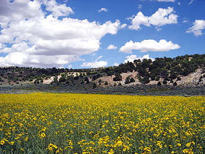
Easy, some route finding needed by 122intheshade   Mount Trumbull is on the north rim of the Grand Canyon. If you've ever walked along the south rim, perhaps you've seen a sign pointing to Mount Trumbull, 80 miles away. If only it were that close . . . Mount Trumbull is on the north rim of the Grand Canyon. If you've ever walked along the south rim, perhaps you've seen a sign pointing to Mount Trumbull, 80 miles away. If only it were that close . . .If you've only seen the south rim, do yourself a favor, carve out a few days, and head north. You can either go by way of Las Vegas and St. George, Utah, on the west or Jacob Lake and Fredonia on the east. An invaluable resource is the Arizona Strip BLM map (if only the Phoenix BLM office had one!), which offers so many possibilities, you'll never want to leave. Mount Trumbull is about 50 miles and 3 hours down bumpy dirt roads from either St. George or Fredonia. You will pass a ranger station/house, but there are no collection facilities for the entry fee. Save the money for a wheel alignment when you get home. If you're in St. George, stop at the Arizona Strip BLM office. Sorry to spend so much time about getting there, but it does take planning, a good map, and a LOT of driving. You will not see many people if any, so be prepared for vehicle problems. Your cell phone WILL NOT WORK out here, even on top of Mt. Trumbull!
[ 7th paragraph deciphers the situation ] Mount Trumbull, like most of the mountains in northern Arizona, is an old volcano. Sunset Crater near Flagstaff is the epitome and best example. I said "scramble up" because where the trail ends, cinders several inches deep cover the mountain the rest of the way up. You can follow footprints up and hope the person before you knew where he was going. But generally, if you keep going up in a zig-zag (much as a skier would go uphill), you'll be OK. One thing you will want to do at various points on the hike is to get a compass reading on where your vehicle is parked. That way, on the way down, you'll know where you need to end up, and eventually, you'll hit the trail. As for the summit, there is a marker and a register. So I've read; I couldn't find it. There is described a "false summit" where you think you're at the top and can't go any higher. That's where I ended up. After having some trail mix and wandering around, I went back down. I went in July, and it was pleasantly cool. The views are terrific when not obscured by the pines. After the hike, do yourself a favor and drive to Toroweap, on the north rim. There are plenty of places to camp, and there might actually be a few people there. It is one of the most gorgeous overlooks on the Grand Canyon. It's also one of the scariest - there are no rails, it's very windy, and a lo-o-ong way down. You won't see God, but you'll know He was there. Check this map for directions. Please note, it is in the National Park, so a backcountry permit is required to camp. You might be able to snag a last-minute permit at the North Rim Backcountry Office; call ahead to be sure.
Arizona Strip - Arizona Strip BLM Division Details The Mt. Trumbull trail quickly ascends the south slope of this high basalt-capped mesa. From the southern rim of the basalt cap, the trail ends and the final mile to the summit on the north edge of the mesa is trailless. Once atop the mesa the route to the summit passes through a beautiful forest of ponderosa pine. At the northern edge of the mesa, broad sweeping views of the heart of the Arizona Strip, as well as much of southern Utah, await the persistent hiker. Check out the Official Route and Triplogs. Leave No Trace and +Add a Triplog after your hike to support this local community. | |||||||||||||||||||||||||||||||||||||||||||||||||||||||||||||||||||||||||||||||||||||||||||||||||||||||||||||||||||||||||||||||||||||||||||||||||||||||||||||||||||||||||||||||||||||||||||||||||||||||||||||||||||||||