 Route Editor

| Guide | ♦ | 5 Triplogs | 0 Topics |
details | drive | no permit | forecast | route |
stats |
photos | triplogs | topics | location |
| 31 | 5 | 0 |
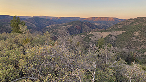
The Other Way to Hell by chumley   Overview OverviewHellsgate Trail #37 is a 10-mile trail that crosses the 1000-foot-deep gorge carved by Tonto Creek at its confluence with Haigler Creek. Due to the ease of access and proximity to population centers, the most common use occurs along the northern segment of the trail. See Hellsgate 37 ( North ) for a description of that hike. This guide covers the less-common southern segment of trail #37, which starts in a remote area west of Young.
See the driving directions below for details on the route, but plan on at least an hour to get from Young to the trailhead along increasingly rough roads the farther you get. A high-clearance 4wd vehicle is required. I would not recommend attempting it in a Subaru or other hybrid-type all-wheel-drive vehicle. There is some cell service via Verizon at the trailhead and a few spots along the 13-mile drive so you can get a phone call or text out, but don't plan on streaming Netflix. Hike The trailhead begins at a switchback in the middle of a very rough, steep hill in the road. It's better to park a couple hundred yards before the trailhead in the saddle at the bottom of the hill. Unfortunately, there are no shade options for parking, so your vehicle will bake in the sun during your hike. You may hike up the road to the official trailhead or save a few feet of elevation gain by simply following the short use path from the saddle that traverses the hill and connects to the official trail. The route follows an old two-track closed to vehicle traffic but appears to be occasionally poached by OHV violators. Regardless, it's easy to follow on foot. The first 1.5 miles descends moderately with a couple of light climbs as the route follows a rolling ridgeline. Shortly after passing the Hellsgate Wilderness sign, the old road takes a precipitous drop straight down the hill, dropping 400 feet in 0.4 miles. The old roadbed does not provide ideal footing and is covered in baseball-sized rocks. Some might describe this footing as complete misery. After the steepest of the road descent, it switches back and traverses down a wooded hillside to where it ends at the crossing of Smoky Hollow. This is a picturesque area of large shady oaks surrounded by desert grasses reminiscent of the terrain in the foothills of the sky islands found 150 miles south of here. After crossing Smoky Hollow, the now single-track traverses the hillside above the drainage, staying at a similar elevation, and even climbing a bit. As of this writing, there are a few spots here where you can easily lose the route in the grass and scrub-covered hillside. But some steady attention should have you on track before the final steep descent to Haigler Creek. The last quarter mile drops 300 feet, but the sight of a bright green canopy of shade trees and the sound of flowing water should motivate you to finish the task ahead! Water Sources Expect to find water only once reaching the bottom of the trail. Two cattle tanks along the way are unreliable, and Smoky Hollow runs only rarely during runoff events. While both Tonto and Haigler creeks are reliable sources of water, both are susceptible to flooding and are often heavily turbid, and may be difficult to filter for drinking. Camping There are four suitable sites for camping at the end of the trail. First is on the peninsula above the confluence of the two creeks. Two more straddle opposite sides of where the trail crosses Tonto Creek heading up to the north trailhead, and a fourth is located 50 feet downstream of the confluence on a shaded bench on the west side of the creek. Backpackers should consider wag bags for human waste as the narrow canyon limits responsible options for burial, and simple use makes those locations gross. As always, pack out toilet paper -- NOBODY wants to see your sh*t tickets! Warning This area is extremely remote and very rugged. While there are scattered junipers to seek shade, the hike is largely exposed and can be very hot in warmer months. Similarly, it is exposed to severe weather during the monsoon with no opportunity for shelter. The sign at the more frequently visited north trailhead is clear. Access from the south should take these cautions into account and multiply them.
Check out the Official Route and Triplogs. Leave No Trace and +Add a Triplog after your hike to support this local community. One-Way Notice This hike is listed as One-Way. When hiking several trails on a single "hike", log it with a generic name that describes the hike. Then link the trails traveled, check out the example. | ||||||||||||||||||||||||||||||||||||||||||||||||||||||||||||||||||||||||||||||||||||||||||||||||


